
Doe een donatie
Rust jezelf uit voor je volgende avontuur:
Als Amazon-partner verdient deze site een commissie op in aanmerking komende aankopen, zonder extra kosten voor jou.
Topografische kaart Fatu Huku
Klik op de kaart om de hoogte weer te geven.
Doe een donatie
Rust jezelf uit voor je volgende avontuur:
Als Amazon-partner verdient deze site een commissie op in aanmerking komende aankopen, zonder extra kosten voor jou.
Fatu Huku
The island is essentially a huge rock, looming steep-sided out of the ocean and rising to a flattened plateau with a maximum elevation of 361 metres (1,184 ft). Fatu Huku is the youngest of the volcanic Marquesas Islands, estimated to be only 1.3 million years old which accounts, in part, for its ruggedness as erosion has not yet carved out valleys and beaches. Coral is rare in the Marquesas, but a fossilized ancient coral reef is found at the higher elevations of Fatu Huku. The island is also surrounded by a roughly triangular-shaped barrier reef that is completely submerged, but can faintly be seen on satellite images.
Doe een donatie
Rust jezelf uit voor je volgende avontuur:
Als Amazon-partner verdient deze site een commissie op in aanmerking komende aankopen, zonder extra kosten voor jou.
Over deze kaart
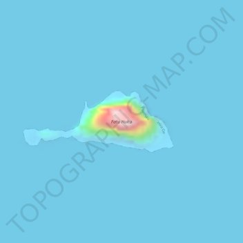
Naam: Topografische kaart Fatu Huku, hoogte, reliëf.
Gemiddelde hoogte: 8 m
Minimale hoogte: -12 m
Maximale hoogte: 342 m
Doe een donatie
Rust jezelf uit voor je volgende avontuur:
Als Amazon-partner verdient deze site een commissie op in aanmerking komende aankopen, zonder extra kosten voor jou.
Andere topografische kaarten
Klik op een kaart om zijn topografie, zijn hoogte en zijn reliëf te bekijken.
Moho Tani
France > French Polynesia > Marquesas Islands > Hiva Oa
It is a high island, with its highest elevation (520 meters) in the south, and its overall shape resembles the back of a whale.
Gemiddelde hoogte: 41 m