
Topografische kaart Wytheville
Interactieve kaart
Klik op de kaart om de hoogte weer te geven.
Over deze kaart
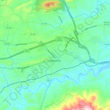
Naam: Topografische kaart Wytheville, hoogte, reliëf.
Locatie: Wytheville, Wythe County, Virginia, 24382, United States (36.92258 -81.13589 36.98165 -81.03117)
Gemiddelde hoogte: 720 m
Minimale hoogte: 621 m
Maximale hoogte: 1.059 m
Due to its elevation, the climate of Wytheville is either classified as mountain temperate or humid subtropical (Köppen Cfb or Cfa, respectively), and the town straddles the border between USDA Plant Hardiness Zones 6B and 7A. Summers are warm and humid, although significantly cooler than low-elevation places within the state, with only 4.6 days of 90 °F (32 °C)+ highs annually, and winters are generally cool to cold with occasional intervening warm periods and 11 nights of sub-10 °F (−12 °C) lows. Monthly mean temperatures range from 32.9 °F (0.5 °C) in January to 71.7 °F (22.1 °C) in July. Snowfall averages 20.5 inches (52 cm) per season and generally occurs from December to March.
Andere topografische kaarten
Klik op een kaart om zijn topografie, zijn hoogte en zijn reliëf te bekijken.
Petunia
United States > Virginia > Wythe County > Wytheville
Petunia, Wytheville, Wythe County, Virginia, 24382, United States
Gemiddelde hoogte: 707 m
Bethany
United States > Virginia > Wythe County
Bethany, Wythe County, Virginia, 24312, United States
Gemiddelde hoogte: 702 m
Austinville
United States > Virginia > Wythe County
Austinville, Wythe County, Virginia, 24312, United States
Gemiddelde hoogte: 645 m
Fort Chiswell
United States > Virginia > Wythe County > Fort Chiswell
Fort Chiswell, Wythe County, Virginia, United States
Gemiddelde hoogte: 674 m
Rural Retreat
United States > Virginia > Wythe County
Rural Retreat, Wythe County, Virginia, United States
Gemiddelde hoogte: 777 m
Jett
United States > Virginia > Wythe County > Jett
Jett, Wythe County, Virginia, 24313, United States
Gemiddelde hoogte: 664 m
Max Meadows
United States > Virginia > Wythe County > Max Meadows
Max Meadows, Wythe County, Virginia, United States
Gemiddelde hoogte: 662 m