
Topografische kaart Mammoth Mountain
Interactieve kaart
Klik op de kaart om de hoogte weer te geven.
Over deze kaart
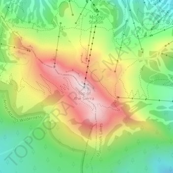
Naam: Topografische kaart Mammoth Mountain, hoogte, reliëf.
Gemiddelde hoogte: 3.011 m
Minimale hoogte: 2.730 m
Maximale hoogte: 3.368 m
Mammoth Mountain is a lava dome complex in Mono County, California. It lies in the southwestern corner of the Long Valley Caldera and consists of about 12 rhyodacite and dacite overlapping domes. These domes formed in a long series of eruptions from 110,000 to 57,000 years ago, building a volcano that reaches 11,059 feet (3,371 m) in elevation. During this time, massive dacite eruptions occurred roughly every 5000 years. The volcano is still active with minor eruptions, the largest of which was a minor phreatic (steam) eruption 700 years ago.
Andere topografische kaarten
Klik op een kaart om zijn topografie, zijn hoogte en zijn reliëf te bekijken.
Lake Mary
United States > California > Mono County > Mammoth Lakes
Lake Mary, Mammoth Lakes, Mono County, California, United States
Gemiddelde hoogte: 2.866 m