
Topografische kaart Recollet Falls
Klik op de kaart om de hoogte weer te geven.
Over deze kaart
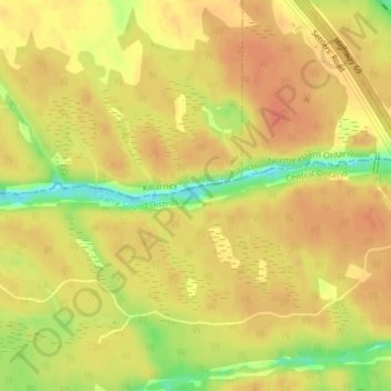
Naam: Topografische kaart Recollet Falls, hoogte, reliëf.
Gemiddelde hoogte: 206 m
Minimale hoogte: 175 m
Maximale hoogte: 218 m
Andere topografische kaarten
Klik op een kaart om zijn topografie, zijn hoogte en zijn reliëf te bekijken.
Spring Lake
Canada > Ontario > Parry Sound District > Unorganized Centre Parry Sound
Gemiddelde hoogte: 317 m
Key River
Canada > Ontario > Parry Sound District > Unorganized Centre Parry Sound
Gemiddelde hoogte: 193 m
Magnetawan River
Canada > Ontario > Parry Sound District > Unorganized Centre Parry Sound
Gemiddelde hoogte: 198 m
Pickerel River
Canada > Ontario > Parry Sound District > Unorganized Centre Parry Sound
Gemiddelde hoogte: 200 m
Harris Lake
Canada > Ontario > Parry Sound District > Unorganized Centre Parry Sound
Gemiddelde hoogte: 209 m
Ferguson Island
Canada > Ontario > Parry Sound District > Unorganized Centre Parry Sound
Gemiddelde hoogte: 206 m
Clear Lake
Canada > Ontario > Parry Sound District > Unorganized Centre Parry Sound
Gemiddelde hoogte: 236 m
Cole Lake
Canada > Ontario > Parry Sound District > Unorganized Centre Parry Sound
Gemiddelde hoogte: 216 m
Grundy Lake Provincial Park
Canada > Ontario > Parry Sound District > Unorganized Centre Parry Sound
Gemiddelde hoogte: 197 m
Key River
Canada > Ontario > Parry Sound District > Unorganized Centre Parry Sound
Gemiddelde hoogte: 194 m
Culin Lake
Canada > Ontario > Parry Sound District > Unorganized Centre Parry Sound > Arnstein
Gemiddelde hoogte: 230 m
Bob's Lake
Canada > Ontario > Parry Sound District > Unorganized Centre Parry Sound
Gemiddelde hoogte: 255 m
Restoule Lake
Canada > Ontario > Parry Sound District > Unorganized Centre Parry Sound
Gemiddelde hoogte: 245 m
McNeil's Island
Canada > Ontario > Parry Sound District > Unorganized Centre Parry Sound > Port Loring
Gemiddelde hoogte: 213 m