
Topografische kaart Coalinga
Interactieve kaart
Klik op de kaart om de hoogte weer te geven.
Coalinga
Coalinga is located 52 miles (84 km) southwest of Fresno, at an elevation of 673 feet (205 m). The topography is generally level, suitable for a number of field crops which do not require large amounts of water. It is located near the eastern foothills of the Diablo Range.
Over deze kaart
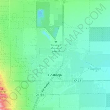
Naam: Topografische kaart Coalinga, hoogte, reliëf.
Locatie: Coalinga, Fresno County, California, United States (36.12052 -120.37562 36.18044 -120.32175)
Gemiddelde hoogte: 216 m
Minimale hoogte: 180 m
Maximale hoogte: 347 m