
Topografische kaart Saint-Jean-de-la-Forêt
Interactieve kaart
Klik op de kaart om de hoogte weer te geven.
Over deze kaart
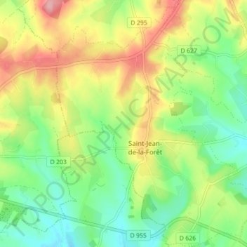
Naam: Topografische kaart Saint-Jean-de-la-Forêt, hoogte, reliëf.
Gemiddelde hoogte: 196 m
Minimale hoogte: 144 m
Maximale hoogte: 270 m
Andere topografische kaarten
Klik op een kaart om zijn topografie, zijn hoogte en zijn reliëf te bekijken.
Préaux-du-Perche
France > Normandie > Orne > Perche en Nocé
Préaux-du-Perche, Perche en Nocé, Mortagne-au-Perche, Orne, Normandie, France métropolitaine, 61340, France
Gemiddelde hoogte: 147 m
Le Brûlé
France > Normandie > Orne > Perche en Nocé
Le Brûlé, Colonard-Corubert, Perche en Nocé, Mortagne-au-Perche, Orne, Normandie, France métropolitaine, 61340, France
Gemiddelde hoogte: 187 m
Le Rosier
France > Normandie > Orne > Perche en Nocé
Le Rosier, Préaux-du-Perche, Perche en Nocé, Mortagne-au-Perche, Orne, Normandie, France métropolitaine, 61340, France
Gemiddelde hoogte: 158 m
Dancé
France > Normandie > Orne > Perche en Nocé
Dancé, Perche en Nocé, Mortagne-au-Perche, Orne, Normandie, France métropolitaine, 61340, France
Gemiddelde hoogte: 147 m
Saint-Aubin-des-Grois
France > Normandie > Orne > Perche en Nocé
Saint-Aubin-des-Grois, Perche en Nocé, Mortagne-au-Perche, Orne, Normandie, France métropolitaine, 61340, France
Gemiddelde hoogte: 163 m