Geolokaliseren
👉 Easily get elevation data in JSON, GeoTIFF and KML formats using Elevation API
Bedankt voor het steunen van deze site ❤️
Doe een donatie

Rust jezelf uit voor je volgende avontuur:

Als Amazon-partner verdient deze site een commissie op in aanmerking komende aankopen, zonder extra kosten voor jou.

Topografische kaart Kollam

Klik op de kaart om de hoogte weer te geven.

👉 Easily get elevation data in JSON, GeoTIFF and KML formats using Elevation API
Bedankt voor het steunen van deze site ❤️
Doe een donatie

Rust jezelf uit voor je volgende avontuur:

Als Amazon-partner verdient deze site een commissie op in aanmerking komende aankopen, zonder extra kosten voor jou.

Kollam

Cosmas Indicopleustes, a Greek Nestorian sailor, in his book the Christian Topography who visited the Malabar Coast in 550, mentions an enclave of Christian believers in Male (Malabar Coast). He writes, "In the island of Tabropane (Ceylon), there is a church of Christians, and clerics and faithful. Likewise at Male, where the pepper grows, and in the farming community of Kalliana (Kalliankal at Nillackal) there is also a bishop consecrated in Persia in accordance with the Nicea Sunnahadose of 325 AD." The Nestorian Patriarch Jesujabus, who died in 660 AD, mentions Kollam in his letter to Simon, Metropolitan of Persia.

Wikipedia (CC-BY-SA 3.0)

👉 Easily get elevation data in JSON, GeoTIFF and KML formats using Elevation API
Bedankt voor het steunen van deze site ❤️
Doe een donatie

Rust jezelf uit voor je volgende avontuur:

Als Amazon-partner verdient deze site een commissie op in aanmerking komende aankopen, zonder extra kosten voor jou.

Over deze kaart

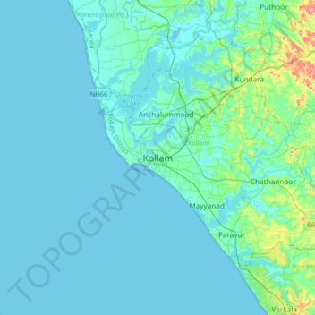
Naam: Topografische kaart Kollam, hoogte, reliëf.

Locatie: Kollam, Kerala, 691001, India (8.72705 76.43067 9.04705 76.75067)

Gemiddelde hoogte: 11 m

Minimale hoogte: -2 m

Maximale hoogte: 115 m

Andere topografische kaarten

Klik op een kaart om zijn topografie, zijn hoogte en zijn reliëf te bekijken.

Ashtamudi Lake

India > Kerala > Kollam > Kottayathukadavu

Ashtamudi Lake (Ashtamudi Kayal), in the Kollam District of the Indian state of Kerala, is the most visited backwater and lake in the state. It possesses a unique wetland ecosystem and a large palm-shaped (also described as octopus-shaped) water body, second only in size to the Vembanad estuary ecosystem of…

Gemiddelde hoogte: 6 m

Mukhathala Kulam

India > Kerala > Kollam > Thrikkovilvattom

Gemiddelde hoogte: 18 m

Kollam

India > Kerala > Kollam > Eravipuram

Gemiddelde hoogte: 9 m

Pozhikara Temple Pond

India > Kerala > Kollam > Paravur

Gemiddelde hoogte: 5 m

Kundara

India > Kerala > Kollam > Kundara

Gemiddelde hoogte: 32 m

Ithikkara

India > Kerala > Kollam > Nellettil

Gemiddelde hoogte: 35 m

Rust jezelf uit voor je volgende avontuur:

🦟Tekenpincetten - Verwijder teken veilig na een boswandeling
📖Wandelgidsen België - Ontdek de mooiste routes in Vlaanderen en Wallonië
🔋Outdoor Powerbanks - Laad je smartphone of GPS op in de natuur
🪑Lichtgewicht Vouwstoelen - Rust comfortabel uit met uitzicht op de vallei
🚴Fietstassen - Waterdichte tassen voor fietsvakanties door België

Als Amazon-partner verdient deze site een commissie op in aanmerking komende aankopen, zonder extra kosten voor jou.