
Topografische kaart Hottentots-Holland Nature Reserve
Interactieve kaart
Klik op de kaart om de hoogte weer te geven.
Over deze kaart
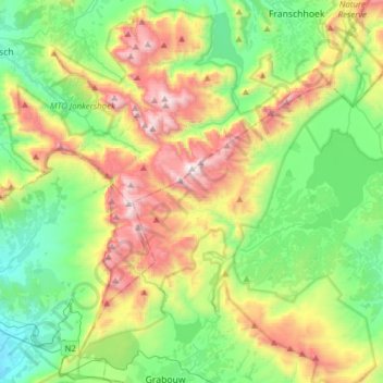
Naam: Topografische kaart Hottentots-Holland Nature Reserve, hoogte, reliëf.
Gemiddelde hoogte: 557 m
Minimale hoogte: 26 m
Maximale hoogte: 1.586 m
Andere topografische kaarten
Klik op een kaart om zijn topografie, zijn hoogte en zijn reliëf te bekijken.
Eerste River
RSA > Western Cape > Stellenbosch Local Municipality
Eerste River, Stellenbosch Local Municipality, Cape Winelands District Municipality, Western Cape, RSA
Gemiddelde hoogte: 372 m
Klapmutskop
RSA > Western Cape > Stellenbosch Local Municipality
Klapmutskop, Stellenbosch Local Municipality, Cape Winelands District Municipality, Western Cape, 7607, RSA
Gemiddelde hoogte: 261 m
Mount Rochelle Nature Reserve
RSA > Western Cape > Stellenbosch Local Municipality
Mount Rochelle Nature Reserve, R45, Stellenbosch Ward 1, Stellenbosch Local Municipality, Cape Winelands District Municipality, Western Cape, 7690, RSA
Gemiddelde hoogte: 844 m