
Doe een donatie
Rust jezelf uit voor je volgende avontuur:
Als Amazon-partner verdient deze site een commissie op in aanmerking komende aankopen, zonder extra kosten voor jou.
Topografische kaart Kirkland Lake
Klik op de kaart om de hoogte weer te geven.
Doe een donatie
Rust jezelf uit voor je volgende avontuur:
Als Amazon-partner verdient deze site een commissie op in aanmerking komende aankopen, zonder extra kosten voor jou.
Kirkland Lake
Kirkland Lake is located in the resource-rich Precambrian Shield, an ancient geological core of the North American continent. Nearby is the Arctic Watershed, a drainage divide at an elevation of 318 m (1,043 ft). Rivers south of that elevation flow into a drainage basin which includes Lake Ontario and the Saint Lawrence River, while rivers north of the watershed flow into Hudson Bay.
Doe een donatie
Rust jezelf uit voor je volgende avontuur:
Als Amazon-partner verdient deze site een commissie op in aanmerking komende aankopen, zonder extra kosten voor jou.
Over deze kaart
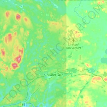
Naam: Topografische kaart Kirkland Lake, hoogte, reliëf.
Gemiddelde hoogte: 332 m
Minimale hoogte: 294 m
Maximale hoogte: 443 m
Doe een donatie
Rust jezelf uit voor je volgende avontuur:
Als Amazon-partner verdient deze site een commissie op in aanmerking komende aankopen, zonder extra kosten voor jou.
Andere topografische kaarten
Klik op een kaart om zijn topografie, zijn hoogte en zijn reliëf te bekijken.
Henwood Lake
Canada > Ontario > Timiskaming District > Unorganized West Timiskaming
Gemiddelde hoogte: 288 m
Doe een donatie
Rust jezelf uit voor je volgende avontuur:
Als Amazon-partner verdient deze site een commissie op in aanmerking komende aankopen, zonder extra kosten voor jou.
Doe een donatie
Rust jezelf uit voor je volgende avontuur:
Als Amazon-partner verdient deze site een commissie op in aanmerking komende aankopen, zonder extra kosten voor jou.
Boston Creek
Canada > Ontario > Timiskaming District > Unorganized West Timiskaming
Gemiddelde hoogte: 300 m
Heart Lake
Canada > Ontario > Timiskaming District > Unorganized West Timiskaming > King Kirkland
Gemiddelde hoogte: 336 m
Doe een donatie
Rust jezelf uit voor je volgende avontuur:
Als Amazon-partner verdient deze site een commissie op in aanmerking komende aankopen, zonder extra kosten voor jou.
Kenabeek
Canada > Ontario > Timiskaming District > Unorganized West Timiskaming
Gemiddelde hoogte: 284 m
Hobart Lake
Canada > Ontario > Timiskaming District > Unorganized West Timiskaming
Gemiddelde hoogte: 305 m
Flanagan Lake
Canada > Ontario > Timiskaming District > Unorganized West Timiskaming
Gemiddelde hoogte: 403 m
Doe een donatie
Rust jezelf uit voor je volgende avontuur:
Als Amazon-partner verdient deze site een commissie op in aanmerking komende aankopen, zonder extra kosten voor jou.
Baptiste Creek;Baptiste Lake
Canada > Ontario > Timiskaming District > Unorganized West Timiskaming
Gemiddelde hoogte: 334 m
Doe een donatie
Rust jezelf uit voor je volgende avontuur:
Als Amazon-partner verdient deze site een commissie op in aanmerking komende aankopen, zonder extra kosten voor jou.