
Doe een donatie
Rust jezelf uit voor je volgende avontuur:
Als Amazon-partner verdient deze site een commissie op in aanmerking komende aankopen, zonder extra kosten voor jou.
Topografische kaart Pikes Peak
Klik op de kaart om de hoogte weer te geven.
Doe een donatie
Rust jezelf uit voor je volgende avontuur:
Als Amazon-partner verdient deze site een commissie op in aanmerking komende aankopen, zonder extra kosten voor jou.
Pikes Peak
The uppermost portion of Pikes Peak, above 14,000 feet (4,300 m) elevation, was declared a National Historic Landmark in 1961.
Doe een donatie
Rust jezelf uit voor je volgende avontuur:
Als Amazon-partner verdient deze site een commissie op in aanmerking komende aankopen, zonder extra kosten voor jou.
Over deze kaart
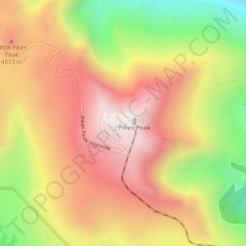
Naam: Topografische kaart Pikes Peak, hoogte, reliëf.
Locatie: Pikes Peak, El Paso County, Colorado, United States (38.84035 -105.04400 38.84045 -105.04390)
Gemiddelde hoogte: 3.902 m
Minimale hoogte: 3.379 m
Maximale hoogte: 4.301 m
Doe een donatie
Rust jezelf uit voor je volgende avontuur:
Als Amazon-partner verdient deze site een commissie op in aanmerking komende aankopen, zonder extra kosten voor jou.
Andere topografische kaarten
Klik op een kaart om zijn topografie, zijn hoogte en zijn reliëf te bekijken.
Colorado Springs
United States > Colorado > El Paso County
At 6,035 feet (1,839 m) the city stands over 1 mile (1.6 km) above sea level. Colorado Springs is near the base of Pikes Peak, which rises 14,115 feet (4,302.31 m) above sea level on the eastern edge of the Southern Rocky Mountains. The city is the largest city north of Mexico above 6000 feet in elevation.
Gemiddelde hoogte: 2.252 m
Colorado Springs
United States > Colorado > El Paso County
Colorado Springs boasts a diverse and striking topography characterized by its high elevation and mountainous terrain. Nestled at approximately 6,035 feet (1,839 meters) above sea level, the city is flanked by the majestic Pikes Peak, which rises dramatically to 14,115 feet (4,302 meters), forming part of the…
Gemiddelde hoogte: 2.252 m
Palmer Lake
United States > Colorado > El Paso County
The town marks the top of the Palmer Divide, a ridge running from Palmer Lake eastward which separates the Arkansas River drainage to the south from the Platte River drainage to the north. The highest point of the divide is about 7,700 feet (2,300 m) above sea level at Vollmer Hill located in the Black Forest.…
Gemiddelde hoogte: 2.302 m
Doe een donatie
Rust jezelf uit voor je volgende avontuur:
Als Amazon-partner verdient deze site een commissie op in aanmerking komende aankopen, zonder extra kosten voor jou.
Black Forest
United States > Colorado > El Paso County
The Black Forest CDP has an area of 64,447 acres (260.807 km2), including 37 acres (0.150 km2) of water. A possible highpoint for the Black Forest area is Vollmer Hill at 7704 feet (2348.2 meters) feet based on a traditional USGS Topographic map.
Gemiddelde hoogte: 2.208 m
Doe een donatie
Rust jezelf uit voor je volgende avontuur:
Als Amazon-partner verdient deze site een commissie op in aanmerking komende aankopen, zonder extra kosten voor jou.
Monument
United States > Colorado > El Paso County
Monument experiences a hemiboreal continental climate (Köppen Dfb) with warm, relatively rainy summers and cold, snowy winters. As with many areas of Colorado, Monument experiences a lot of sunshine with an average of 250 sunny days per year. The semi-arid climate keeps the dew point very low in Monument…
Gemiddelde hoogte: 2.160 m
Doe een donatie
Rust jezelf uit voor je volgende avontuur:
Als Amazon-partner verdient deze site een commissie op in aanmerking komende aankopen, zonder extra kosten voor jou.
Rampart Reservoir
United States > Colorado > El Paso County
The reservoir supplies water to the Tesla Hydroelectric Facility. Colorado Springs Utilities built and operates this hydroelectric power plant, which opened in 1997. Water from the reservoir flows down a shaft called the Stanley Tunnel and then into the turbines in a powerhouse located in the foothills west of…
Gemiddelde hoogte: 2.765 m
Alamo Square Park
United States > Colorado > El Paso County > Colorado Springs
Gemiddelde hoogte: 1.831 m
Garden of the Gods Park
United States > Colorado > El Paso County > Colorado Springs
Gemiddelde hoogte: 1.982 m
Doe een donatie
Rust jezelf uit voor je volgende avontuur:
Als Amazon-partner verdient deze site een commissie op in aanmerking komende aankopen, zonder extra kosten voor jou.
Palmer Lake
United States > Colorado > El Paso County
The town marks the top of the Palmer Divide, a ridge running from Palmer Lake eastward which separates the Arkansas River drainage to the south from the Platte River drainage to the north. The highest point of the divide is about 7,700 feet (2,300 m) above sea level at Vollmer Hill located in the Black Forest.…
Gemiddelde hoogte: 2.302 m
Cheyenne Mountain State Park
United States > Colorado > El Paso County > Colorado Springs
Gemiddelde hoogte: 2.142 m
Doe een donatie
Rust jezelf uit voor je volgende avontuur:
Als Amazon-partner verdient deze site een commissie op in aanmerking komende aankopen, zonder extra kosten voor jou.
Air Force Academy
United States > Colorado > El Paso County > Colorado Springs
The campus of the academy covers 18,455 acres (29 sq mi; 75 km2) on the east side of the Rampart Range of the Rocky Mountains, just north of Colorado Springs. Its elevation is normally given as 7,258 feet (2,212 m) above sea level, which is at the cadet area. The academy was designed by Skidmore, Owings and…
Gemiddelde hoogte: 2.158 m
Palmer Lake
United States > Colorado > El Paso County
The town marks the top of the Palmer Divide, a ridge running from Palmer Lake eastward which separates the Arkansas River drainage to the south from the Platte River drainage to the north. The highest point of the divide is about 7,700 feet (2,300 m) above sea level at Vollmer Hill located in the Black Forest.…
Gemiddelde hoogte: 2.302 m
Colorado Springs
United States > Colorado > El Paso County
At 6,035 feet (1,839 m) the city stands over 1 mile (1.6 km) above sea level. Colorado Springs is near the base of Pikes Peak, which rises 14,115 feet (4,302.31 m) above sea level on the eastern edge of the Southern Rocky Mountains. The city is the largest city north of Mexico above 6000 feet in elevation.
Gemiddelde hoogte: 2.252 m
Doe een donatie
Rust jezelf uit voor je volgende avontuur:
Als Amazon-partner verdient deze site een commissie op in aanmerking komende aankopen, zonder extra kosten voor jou.
Monument
United States > Colorado > El Paso County
Monument experiences a hemiboreal continental climate (Köppen Dfb) with warm, relatively rainy summers and cold, snowy winters. The semi-arid climate keeps the dew point very low in Monument year-round which causes the air to feel quite dry. Monument is part of the Front Range urban corridor and lies on the…
Gemiddelde hoogte: 2.160 m
Doe een donatie
Rust jezelf uit voor je volgende avontuur:
Als Amazon-partner verdient deze site een commissie op in aanmerking komende aankopen, zonder extra kosten voor jou.
Sleeping Giant
United States > Colorado > El Paso County > Colorado Springs
Gemiddelde hoogte: 1.971 m
Garden of the Gods Park
United States > Colorado > El Paso County > Colorado Springs
Gemiddelde hoogte: 1.982 m
Colorado Springs
United States > Colorado > El Paso County
At 6,035 feet (1,839 m) the city stands over 1 mile (1.6 km) above sea level. Colorado Springs is near the base of Pikes Peak, which rises 14,115 feet (4,302.31 m) above sea level on the eastern edge of the Southern Rocky Mountains. The city is the largest city north of Mexico above 6000 feet in elevation.
Gemiddelde hoogte: 2.252 m
Doe een donatie
Rust jezelf uit voor je volgende avontuur:
Als Amazon-partner verdient deze site een commissie op in aanmerking komende aankopen, zonder extra kosten voor jou.
Silverwood Park
United States > Colorado > El Paso County > Colorado Springs
Gemiddelde hoogte: 2.082 m