
Topografische kaart Qualicum Bay
Interactieve kaart
Klik op de kaart om de hoogte weer te geven.
Over deze kaart
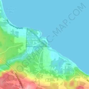
Naam: Topografische kaart Qualicum Bay, hoogte, reliëf.
Gemiddelde hoogte: 21 m
Minimale hoogte: 0 m
Maximale hoogte: 111 m
Andere topografische kaarten
Klik op een kaart om zijn topografie, zijn hoogte en zijn reliëf te bekijken.
Dunsmuir
Canada > British Columbia > Regional District of Nanaimo > Area H (Lighthouse Country)
Dunsmuir, Area H (Lighthouse Country), Regional District of Nanaimo, British Columbia, Canada
Gemiddelde hoogte: 46 m