
Topografische kaart Riverside
Interactieve kaart
Klik op de kaart om de hoogte weer te geven.
Over deze kaart
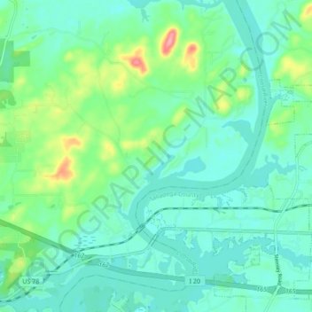
Naam: Topografische kaart Riverside, hoogte, reliëf.
Locatie: Riverside, St. Clair County, Alabama, 35135, United States (33.58647 -86.24213 33.65764 -86.16461)
Gemiddelde hoogte: 157 m
Minimale hoogte: 132 m
Maximale hoogte: 241 m
Andere topografische kaarten
Klik op een kaart om zijn topografie, zijn hoogte en zijn reliëf te bekijken.
Riverside
United States > Alabama > St. Clair County
Riverside, St. Clair County, Alabama, 35135, United States
Gemiddelde hoogte: 159 m
Ragland
United States > Alabama > St. Clair County
Ragland, St. Clair County, Alabama, United States
Gemiddelde hoogte: 188 m
Springville
United States > Alabama > St. Clair County
Springville, St. Clair County, Alabama, 35146, United States
Gemiddelde hoogte: 264 m
Walkerton
United States > Alabama > St. Clair County > Pell City
Walkerton, Pell City, St. Clair County, Alabama, 35125, United States
Gemiddelde hoogte: 176 m
Pell City
United States > Alabama > St. Clair County
Pell City, St. Clair County, Alabama, United States
Gemiddelde hoogte: 167 m
Ashville
United States > Alabama > St. Clair County
Ashville, St. Clair County, Alabama, 35953, United States
Gemiddelde hoogte: 190 m