
Topografische kaart Cavan-Belturbet Municipal District
Interactieve kaart
Klik op de kaart om de hoogte weer te geven.
Over deze kaart
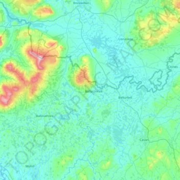
Naam: Topografische kaart Cavan-Belturbet Municipal District, hoogte, reliëf.
Locatie: Cavan-Belturbet Municipal District, County Cavan, Irland (53.93434 -8.05818 54.30454 -7.26230)
Gemiddelde hoogte: 111 m
Minimale hoogte: 37 m
Maximale hoogte: 653 m
Andere topografische kaarten
Klik op een kaart om zijn topografie, zijn hoogte en zijn reliëf te bekijken.
Lear
Lear, Canningstown ED, Bailieborough-Cootehill Municipal District, County Cavan, Ulster, Irland
Gemiddelde hoogte: 189 m
Swanlinbar
Swanlinbar, Cavan-Belturbet Municipal District, County Cavan, Irland
Gemiddelde hoogte: 97 m
Gubnafarna
Gubnafarna, Kinawley ED, Cavan-Belturbet Municipal District, County Cavan, Irland
Gemiddelde hoogte: 178 m