
Topografische kaart Elon
Interactieve kaart
Klik op de kaart om de hoogte weer te geven.
Over deze kaart
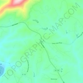
Naam: Topografische kaart Elon, hoogte, reliëf.
Locatie: Elon, Amherst County, Virginia, 24574, United States (37.49764 -79.21503 37.53764 -79.17503)
Gemiddelde hoogte: 257 m
Minimale hoogte: 171 m
Maximale hoogte: 518 m
Andere topografische kaarten
Klik op een kaart om zijn topografie, zijn hoogte en zijn reliëf te bekijken.
Monroe
United States > Virginia > Amherst County
Monroe, Amherst County, Virginia, 24572, United States
Gemiddelde hoogte: 239 m
Willow
United States > Virginia > Amherst County
Willow, Amherst County, Virginia, United States
Gemiddelde hoogte: 454 m
Clifford
United States > Virginia > Amherst County
Clifford, Amherst County, Virginia, United States
Gemiddelde hoogte: 225 m
Oronoco
United States > Virginia > Amherst County
Oronoco, Amherst County, Virginia, United States
Gemiddelde hoogte: 689 m
Madison Heights
United States > Virginia > Amherst County > Madison Heights
Madison Heights, Wright Shop, Madison Heights, Amherst County, Virginia, United States
Gemiddelde hoogte: 220 m
Snowden
United States > Virginia > Amherst County
Snowden, Amherst County, Virginia, United States
Gemiddelde hoogte: 327 m
Mount Pleasant
United States > Virginia > Amherst County
Mount Pleasant, Amherst County, Virginia, United States
Gemiddelde hoogte: 954 m
Madison Heights
United States > Virginia > Amherst County
Madison Heights, Amherst County, Virginia, 24505, United States
Gemiddelde hoogte: 217 m
Long Mountain
United States > Virginia > Amherst County
Long Mountain, Amherst County, Virginia, United States
Gemiddelde hoogte: 567 m
Amherst
United States > Virginia > Amherst County
Amherst, Amherst County, Virginia, United States
Gemiddelde hoogte: 217 m