
Topografische kaart Canyon City
Interactieve kaart
Klik op de kaart om de hoogte weer te geven.
Over deze kaart
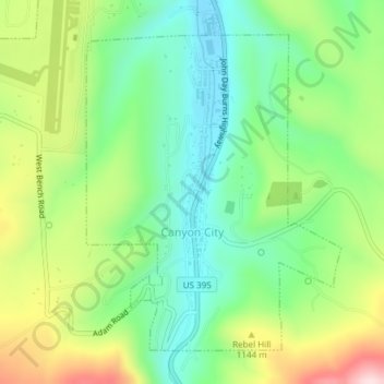
Naam: Topografische kaart Canyon City, hoogte, reliëf.
Locatie: Canyon City, Grant County, Oregon, 97820, United States (44.38124 -118.96065 44.40346 -118.93560)
Gemiddelde hoogte: 1.078 m
Minimale hoogte: 955 m
Maximale hoogte: 1.293 m
The city is at an elevation of about 3,200 feet (980 m). Between Canyon City and Burns, to the south, Route 395 passes through parts of the Malheur National Forest. According to the United States Census Bureau, the town has a total area of 1.41 square miles (3.65 km2), all land.