
Topografische kaart Utah County
Interactieve kaart
Klik op de kaart om de hoogte weer te geven.
Over deze kaart
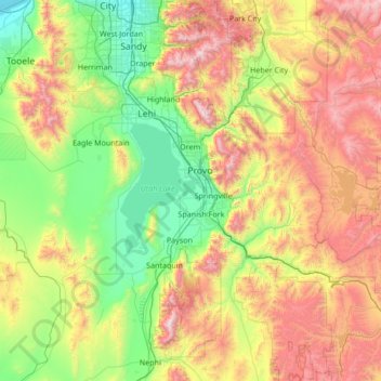
Naam: Topografische kaart Utah County, hoogte, reliëf.
Locatie: Utah County, Utah, United States of America (39.77736 -112.21283 40.57791 -110.85765)
Gemiddelde hoogte: 2.062 m
Minimale hoogte: 1.283 m
Maximale hoogte: 3.581 m
Utah Valley lies at the center of the county, lined by the mountains of the Wasatch Range on the east. Utah Lake occupies a large part of the valley. The elevation ranges from 4,487 feet (1,368 m) above sea level at the lake to 11,928 feet (3,636 m) at the peak of Mount Nebo.
Andere topografische kaarten
Klik op een kaart om zijn topografie, zijn hoogte en zijn reliëf te bekijken.
Daggett County
United States of America > Utah
Daggett County, Utah, 84023, United States of America
Gemiddelde hoogte: 2.267 m
Sandy
United States of America > Utah > Sandy
Sandy, Salt Lake County, Utah, 84092, United States of America
Gemiddelde hoogte: 1.827 m
Salt Lake County
United States of America > Utah
Salt Lake County, Utah, United States of America
Gemiddelde hoogte: 1.811 m
Tooele County
United States of America > Utah
Tooele County, Utah, United States of America
Gemiddelde hoogte: 1.462 m
Duchesne County
United States of America > Utah
Duchesne County, Utah, United States of America
Gemiddelde hoogte: 2.408 m