
Topografische kaart Radziszów
Interactieve kaart
Klik op de kaart om de hoogte weer te geven.
Over deze kaart
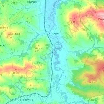
Naam: Topografische kaart Radziszów, hoogte, reliëf.
Gemiddelde hoogte: 262 m
Minimale hoogte: 216 m
Maximale hoogte: 366 m
Andere topografische kaarten
Klik op een kaart om zijn topografie, zijn hoogte en zijn reliëf te bekijken.
Werychów
Poland > Lesser Poland Voivodeship > Kraków County > Balice
Werychów, Balice, gmina Zabierzów, Kraków County, Lesser Poland Voivodeship, 31-083, Poland
Gemiddelde hoogte: 238 m
Bielańsko-Tyniecki Park Krajobrazowy
Poland > Lesser Poland Voivodeship > Kraków County > Krakow
Bielańsko-Tyniecki Park Krajobrazowy, Krakow, gmina Liszki, Kraków County, Lesser Poland Voivodeship, Poland
Gemiddelde hoogte: 239 m
Podzamcze
Poland > Lesser Poland Voivodeship > Kraków County > Korzkiew > Podzamcze
Podzamcze, Korzkiew, gmina Zielonki, Kraków County, Lesser Poland Voivodeship, Poland
Gemiddelde hoogte: 321 m
Czernichów
Poland > Lesser Poland Voivodeship > Kraków County
Czernichów, gmina Czernichów, Kraków County, Lesser Poland Voivodeship, Poland
Gemiddelde hoogte: 219 m
Libertów
Poland > Lesser Poland Voivodeship > Kraków County
Libertów, gmina Mogilany, Kraków County, Lesser Poland Voivodeship, 30-444, Poland
Gemiddelde hoogte: 270 m
Kobylany
Poland > Lesser Poland Voivodeship > Kraków County
Kobylany, gmina Zabierzów, Kraków County, Lesser Poland Voivodeship, Poland
Gemiddelde hoogte: 319 m