
Doe een donatie
Rust jezelf uit voor je volgende avontuur:
Als Amazon-partner verdient deze site een commissie op in aanmerking komende aankopen, zonder extra kosten voor jou.
Topografische kaart Cammarata
Klik op de kaart om de hoogte weer te geven.
Doe een donatie
Rust jezelf uit voor je volgende avontuur:
Als Amazon-partner verdient deze site een commissie op in aanmerking komende aankopen, zonder extra kosten voor jou.
Cammarata
Cammarata is a comune (municipality) in the Province of Agrigento in the Italian region Sicily, located about 60 kilometres (37 mi) southeast of Palermo and about 35 kilometres (22 mi) north of Agrigento on the eponymous mountain, which has an elevation 1,578 metres (5,177 ft) above sea level in a territory rich in forests.
Doe een donatie
Rust jezelf uit voor je volgende avontuur:
Als Amazon-partner verdient deze site een commissie op in aanmerking komende aankopen, zonder extra kosten voor jou.
Over deze kaart
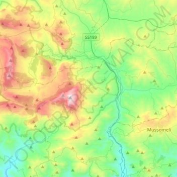
Naam: Topografische kaart Cammarata, hoogte, reliëf.
Locatie: Cammarata, Agrigento, Sicily, 92022, Italy (37.56550 13.54619 37.69501 13.83136)
Gemiddelde hoogte: 598 m
Minimale hoogte: 120 m
Maximale hoogte: 1.562 m
Doe een donatie
Rust jezelf uit voor je volgende avontuur:
Als Amazon-partner verdient deze site een commissie op in aanmerking komende aankopen, zonder extra kosten voor jou.