
Topografische kaart Tillamook County
Interactieve kaart
Klik op de kaart om de hoogte weer te geven.
Over deze kaart
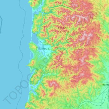
Naam: Topografische kaart Tillamook County, hoogte, reliëf.
Locatie: Tillamook County, Oregon, United States of America (45.04442 -124.09575 45.78360 -123.29927)
Gemiddelde hoogte: 236 m
Minimale hoogte: -3 m
Maximale hoogte: 1.073 m
According to the U.S. Census Bureau, the county has a total area of 1,333 square miles (3,450 km2), of which 1,103 square miles (2,860 km2) is land and 230 square miles (600 km2) (17%) is water. At 3,706 feet (1130 m) in elevation, Rogers Peak is the highest point in the county and the highest in the Northern Oregon Coast Range.
Andere topografische kaarten
Klik op een kaart om zijn topografie, zijn hoogte en zijn reliëf te bekijken.
Cascade Range
United States of America > Oregon
Cascade Range, Wasco County, Oregon, United States of America
Gemiddelde hoogte: 1.241 m