
Doe een donatie
Rust jezelf uit voor je volgende avontuur:
Als Amazon-partner verdient deze site een commissie op in aanmerking komende aankopen, zonder extra kosten voor jou.
Topografische kaart Louisdale
Klik op de kaart om de hoogte weer te geven.
Doe een donatie
Rust jezelf uit voor je volgende avontuur:
Als Amazon-partner verdient deze site een commissie op in aanmerking komende aankopen, zonder extra kosten voor jou.
Over deze kaart
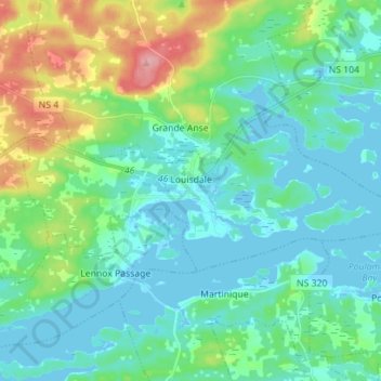
Naam: Topografische kaart Louisdale, hoogte, reliëf.
Gemiddelde hoogte: 26 m
Minimale hoogte: -4 m
Maximale hoogte: 112 m
Doe een donatie
Rust jezelf uit voor je volgende avontuur:
Als Amazon-partner verdient deze site een commissie op in aanmerking komende aankopen, zonder extra kosten voor jou.
Andere topografische kaarten
Klik op een kaart om zijn topografie, zijn hoogte en zijn reliëf te bekijken.
Sporting Mountain
Canada > Nova Scotia > Municipality of the County of Richmond > River Bourgeois
Gemiddelde hoogte: 59 m
Garrets Lake
Canada > Nova Scotia > Municipality of the County of Richmond > Salmon River
Gemiddelde hoogte: 48 m
Comeau Point
Canada > Nova Scotia > Municipality of the County of Richmond > Alderney Point
Gemiddelde hoogte: 11 m
Barachois Pond
Canada > Nova Scotia > Municipality of the County of Richmond > Arichat
Gemiddelde hoogte: 16 m
Doe een donatie
Rust jezelf uit voor je volgende avontuur:
Als Amazon-partner verdient deze site een commissie op in aanmerking komende aankopen, zonder extra kosten voor jou.
Sampson Lake
Canada > Nova Scotia > Municipality of the County of Richmond > Louisdale
Gemiddelde hoogte: 7 m
Crow Island
Canada > Nova Scotia > Municipality of the County of Richmond > Poulamon
Gemiddelde hoogte: 40 m