
Doe een donatie
Rust jezelf uit voor je volgende avontuur:
Als Amazon-partner verdient deze site een commissie op in aanmerking komende aankopen, zonder extra kosten voor jou.
Topografische kaart Bitumount
Klik op de kaart om de hoogte weer te geven.
Doe een donatie
Rust jezelf uit voor je volgende avontuur:
Als Amazon-partner verdient deze site een commissie op in aanmerking komende aankopen, zonder extra kosten voor jou.
Over deze kaart
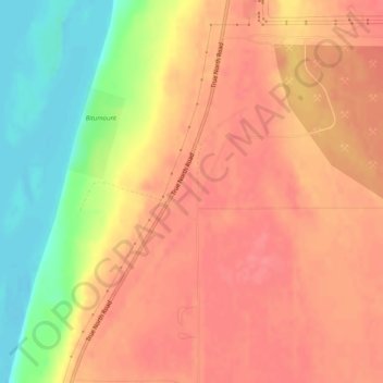
Naam: Topografische kaart Bitumount, hoogte, reliëf.
Locatie: Bitumount, Wood Buffalo, Alberta, Canada (57.37213 -111.64210 57.39213 -111.62210)
Gemiddelde hoogte: 272 m
Minimale hoogte: 227 m
Maximale hoogte: 294 m
Doe een donatie
Rust jezelf uit voor je volgende avontuur:
Als Amazon-partner verdient deze site een commissie op in aanmerking komende aankopen, zonder extra kosten voor jou.
Andere topografische kaarten
Klik op een kaart om zijn topografie, zijn hoogte en zijn reliëf te bekijken.
Fort McMurray
Canada > Alberta > Wood Buffalo
The community lies at a lower elevation than most other parts of Alberta, so under the right conditions it can be a "hot spot" for Alberta.
Gemiddelde hoogte: 345 m
Doe een donatie
Rust jezelf uit voor je volgende avontuur:
Als Amazon-partner verdient deze site een commissie op in aanmerking komende aankopen, zonder extra kosten voor jou.
Fort McKay
Canada > Alberta > Wood Buffalo
Fort McKay (/məˈkaɪ/ mə-KY) or Fort MacKay is a community in northeast Alberta, Canada that is located at the confluence of the Athabasca and MacKay rivers. It is approximately 54 km (34 mi) north of Fort McMurray via Highway 63 and Fort McKay Road. The community has an elevation of 260 m (850 ft).
Gemiddelde hoogte: 259 m
Doe een donatie
Rust jezelf uit voor je volgende avontuur:
Als Amazon-partner verdient deze site een commissie op in aanmerking komende aankopen, zonder extra kosten voor jou.
Fort McMurray
Canada > Alberta > Wood Buffalo
The community lies at a lower elevation than most other parts of Alberta, so under the right conditions it can be a "hot spot" for Alberta.
Gemiddelde hoogte: 346 m
Fort McKay
Canada > Alberta > Wood Buffalo
Fort McKay (/məˈkaɪ/ mə-KY) or Fort MacKay is a community in northeast Alberta, Canada, located at the confluence of the Athabasca and MacKay rivers. It is approximately 54 km (34 mi) north of Fort McMurray via Highway 63 and Fort McKay Road. The community has an elevation of 260 m (850 ft).
Gemiddelde hoogte: 259 m
Doe een donatie
Rust jezelf uit voor je volgende avontuur:
Als Amazon-partner verdient deze site een commissie op in aanmerking komende aankopen, zonder extra kosten voor jou.
Fort McKay
Canada > Alberta > Wood Buffalo
Fort McKay (/məˈkaɪ/ mə-KY) or Fort MacKay is a community in northeast Alberta, Canada, located at the confluence of the Athabasca and MacKay rivers. It is approximately 54 km (34 mi) north of Fort McMurray via Highway 63 and Fort McKay Road. The community has an elevation of 260 m (850 ft).
Gemiddelde hoogte: 259 m