
Doe een donatie
Rust jezelf uit voor je volgende avontuur:
Als Amazon-partner verdient deze site een commissie op in aanmerking komende aankopen, zonder extra kosten voor jou.
Topografische kaart Pindus
Klik op de kaart om de hoogte weer te geven.
Doe een donatie
Rust jezelf uit voor je volgende avontuur:
Als Amazon-partner verdient deze site een commissie op in aanmerking komende aankopen, zonder extra kosten voor jou.
Pindus
The Pindus (also Pindos or Pindhos; Greek: Πίνδος, romanized: Píndos; Albanian: Pindet; Aromanian: Pindu) is a mountain range located in Northern Greece and Southern Albania. It is roughly 160 km (99 mi) long, with a maximum elevation of 2,637 metres (8,652 ft) (Mount Smolikas). Because it runs north to south along much of mainland Greece, the Pindus range is known colloquially as the spine of Greece. The mountain range stretches from near the Greek-Albanian border in southern Albania, entering the Epirus and Macedonia regions in northern Greece down to the north of the Peloponnese. Geologically, it is an extension of the Dinaric Alps, which dominate the western region of the Balkan Peninsula.
Doe een donatie
Rust jezelf uit voor je volgende avontuur:
Als Amazon-partner verdient deze site een commissie op in aanmerking komende aankopen, zonder extra kosten voor jou.
Over deze kaart
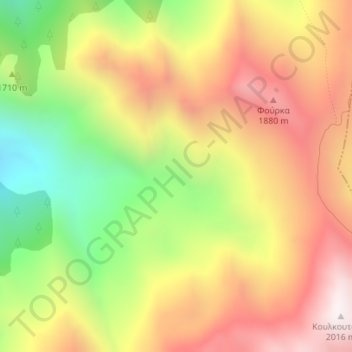
Naam: Topografische kaart Pindus, hoogte, reliëf.
Gemiddelde hoogte: 1.510 m
Minimale hoogte: 942 m
Maximale hoogte: 2.013 m
Doe een donatie
Rust jezelf uit voor je volgende avontuur:
Als Amazon-partner verdient deze site een commissie op in aanmerking komende aankopen, zonder extra kosten voor jou.
Andere topografische kaarten
Klik op een kaart om zijn topografie, zijn hoogte en zijn reliëf te bekijken.
Municipal Unit of Tamasi
Greece > Thessaly and Central Greece > Karditsa Regional Unit
Gemiddelde hoogte: 293 m
Plastiras (Tavropos) Lake
Greece > Thessaly and Central Greece > Karditsa Regional Unit > Plastiras Municipal Unit
Today the lake holds up to 400 million cubic meters of fresh water. It is used for irrigation and as a power source of a hydroelectric plant, but also as the main water source to the city of Karditsa. Due to its altitude (one of the highest in Europe) the Tavropos Reservoir is a popular tourist resort in…
Gemiddelde hoogte: 792 m