
Topografische kaart Gallatin County
Interactieve kaart
Klik op de kaart om de hoogte weer te geven.
Over deze kaart
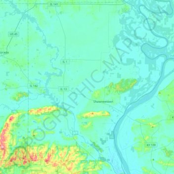
Naam: Topografische kaart Gallatin County, hoogte, reliëf.
Locatie: Gallatin County, Illinois, United States of America (37.57308 -88.37424 37.91621 -88.02502)
Gemiddelde hoogte: 122 m
Minimale hoogte: 99 m
Maximale hoogte: 302 m
Andere topografische kaarten
Klik op een kaart om zijn topografie, zijn hoogte en zijn reliëf te bekijken.
Vergennes
United States of America > Illinois > Vergennes
Vergennes, Jackson County, Illinois, United States of America
Gemiddelde hoogte: 121 m
Cumberland County
United States of America > Illinois
Cumberland County, Illinois, United States of America
Gemiddelde hoogte: 189 m
Pike County
United States of America > Illinois
Pike County, Illinois, United States of America
Gemiddelde hoogte: 184 m
Adams County
United States of America > Illinois
Adams County, Illinois, United States of America
Gemiddelde hoogte: 196 m
Alexander County
United States of America > Illinois
Alexander County, Illinois, United States of America
Gemiddelde hoogte: 112 m
Carroll County
United States of America > Illinois
Carroll County, Illinois, United States of America
Gemiddelde hoogte: 235 m
White County
United States of America > Illinois
White County, Illinois, United States of America
Gemiddelde hoogte: 122 m
Cook County
United States of America > Illinois
Cook County, Illinois, United States of America
Gemiddelde hoogte: 199 m
Bureau County
United States of America > Illinois
Bureau County, Illinois, United States of America
Gemiddelde hoogte: 212 m