
Topografische kaart White Gums
Interactieve kaart
Klik op de kaart om de hoogte weer te geven.
Over deze kaart
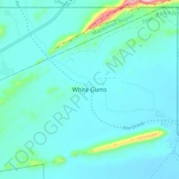
Naam: Topografische kaart White Gums, hoogte, reliëf.
Gemiddelde hoogte: 594 m
Minimale hoogte: 563 m
Maximale hoogte: 818 m
Andere topografische kaarten
Klik op een kaart om zijn topografie, zijn hoogte en zijn reliëf te bekijken.
Nyewente
Australia > Town of Alice Springs
Nyewente, Town of Alice Springs, Northern Territory, 0871, Australia
Gemiddelde hoogte: 597 m
Ilparpa
Australia > Town of Alice Springs
Ilparpa, Town of Alice Springs, Northern Territory, Australia
Gemiddelde hoogte: 581 m
Alice Springs
Australia > Town of Alice Springs
Alice Springs, Town of Alice Springs, Northern Territory, 4992, Australia
Gemiddelde hoogte: 584 m
Mpwetyerre
Australia > Town of Alice Springs
Mpwetyerre, Town of Alice Springs, Northern Territory, 0870, Australia
Gemiddelde hoogte: 592 m
Aper Alwerrkng
Australia > Town of Alice Springs > Aper Alwerrkng
Aper Alwerrkng, Stuart, Town of Alice Springs, Northern Territory, 0871, Australia
Gemiddelde hoogte: 609 m
Connellan
Australia > Town of Alice Springs > Connellan
Connellan, Town of Alice Springs, Northern Territory, 0873, Australia
Gemiddelde hoogte: 548 m
Anzac Hill
Australia > Town of Alice Springs > Alice Springs
Anzac Hill, Alice Springs, Town of Alice Springs, Northern Territory, 0870, Australia
Gemiddelde hoogte: 586 m