
Topografische kaart Mount Tzouhalem
Interactieve kaart
Klik op de kaart om de hoogte weer te geven.
Over deze kaart
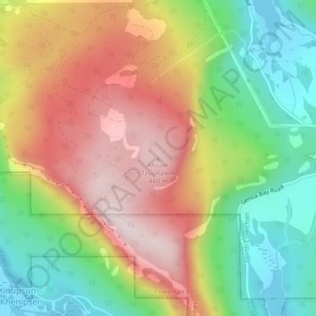
Naam: Topografische kaart Mount Tzouhalem, hoogte, reliëf.
Gemiddelde hoogte: 233 m
Minimale hoogte: 0 m
Maximale hoogte: 492 m
The reserve, at middle elevations (120–280 metres) on the western side of the mountain, faces southwest and has strongly sloping, internally hilly terrain. The Tzuhalem area is a historical harvesting location for the Vancouver Island Coast Salish First Nations. The reserve is a camas harvesting site that was traditionally burned to increase yields and maintain the open, park-like habitat.
Andere topografische kaarten
Klik op een kaart om zijn topografie, zijn hoogte en zijn reliëf te bekijken.
Stoney Hill
Canada > British Columbia > Cowichan Valley Regional District > North Cowichan
Stoney Hill, North Cowichan, Cowichan Valley Regional District, British Columbia, V9L 5T7, Canada
Gemiddelde hoogte: 78 m