
Topografische kaart Llanmartin
Interactieve kaart
Klik op de kaart om de hoogte weer te geven.
Over deze kaart
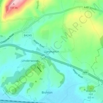
Naam: Topografische kaart Llanmartin, hoogte, reliëf.
Locatie: Llanmartin, Gwent, Wales, NP18 2EG, United Kingdom (51.58028 -2.89603 51.62028 -2.85603)
Gemiddelde hoogte: 48 m
Minimale hoogte: 2 m
Maximale hoogte: 196 m
Andere topografische kaarten
Klik op een kaart om zijn topografie, zijn hoogte en zijn reliëf te bekijken.
Monmouthshire Canal Crumlin Branch
United Kingdom > Wales > Gwent > Newport
Monmouthshire Canal Crumlin Branch, Barrack Hill, Allt-Yr-Yn, Newport, Gwent, Wales, NP20 5EH, United Kingdom
Gemiddelde hoogte: 40 m
Monmouthshire Canal Crumlin Branch
United Kingdom > Wales > Gwent > Newport
Monmouthshire Canal Crumlin Branch, Ridgeway, Allt-Yr-Yn, Newport, Gwent, Wales, NP20 5DX, United Kingdom
Gemiddelde hoogte: 43 m
Parc Seymour
United Kingdom > Wales > Gwent > Newport
Parc Seymour, Penhow, Newport, Gwent, Wales, NP26 3AB, United Kingdom
Gemiddelde hoogte: 107 m
Underwood
United Kingdom > Wales > Gwent > Newport
Underwood, Newport, Gwent, Wales, NP18 2HQ, United Kingdom
Gemiddelde hoogte: 38 m
Bishton
United Kingdom > Wales > Gwent
Bishton, Gwent, Wales, NP18 2DZ, United Kingdom
Gemiddelde hoogte: 21 m
Malpas
United Kingdom > Wales > Gwent > Newport
Malpas, Newport, Gwent, Wales, United Kingdom
Gemiddelde hoogte: 30 m
Rhiwderin
United Kingdom > Wales > Gwent > Newport
Rhiwderin, Newport, Gwent, Wales, NP10 8RN, United Kingdom
Gemiddelde hoogte: 73 m