
Doe een donatie
Rust jezelf uit voor je volgende avontuur:
Als Amazon-partner verdient deze site een commissie op in aanmerking komende aankopen, zonder extra kosten voor jou.
Topografische kaart Galeras
Klik op de kaart om de hoogte weer te geven.
Doe een donatie
Rust jezelf uit voor je volgende avontuur:
Als Amazon-partner verdient deze site een commissie op in aanmerking komende aankopen, zonder extra kosten voor jou.
Galeras
Numerous minor tremors and ash emissions since March 2006 culminated on 12 July 2006 in three explosive eruptions, producing an ash and gas column reaching an altitude of 8 kilometres (5.0 mi). Rock falls and pyroclastic flows were reported from towns as distant as Consacá, 11.4 kilometres (7.1 mi) west of the main crater. The Colombian government has repeatedly ordered evacuations to temporary shelters, of more than 8500 people residing in the highest risk areas surrounding the volcano, with hopes of eventual assistance toward permanent relocation.
Doe een donatie
Rust jezelf uit voor je volgende avontuur:
Als Amazon-partner verdient deze site een commissie op in aanmerking komende aankopen, zonder extra kosten voor jou.
Over deze kaart
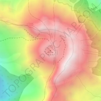
Naam: Topografische kaart Galeras, hoogte, reliëf.
Locatie: Galeras, Consacá, Occidente, Nariño, RAP Pacífico, Colombia (1.22148 -77.35901 1.22158 -77.35891)
Gemiddelde hoogte: 3.847 m
Minimale hoogte: 3.243 m
Maximale hoogte: 4.208 m
Doe een donatie
Rust jezelf uit voor je volgende avontuur:
Als Amazon-partner verdient deze site een commissie op in aanmerking komende aankopen, zonder extra kosten voor jou.