
Topografische kaart Caterham
Interactieve kaart
Klik op de kaart om de hoogte weer te geven.
Over deze kaart
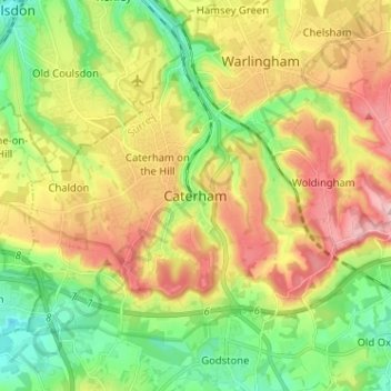
Naam: Topografische kaart Caterham, hoogte, reliëf.
Gemiddelde hoogte: 157 m
Minimale hoogte: 70 m
Maximale hoogte: 270 m
In 1840 Caterham contained a total of 477 residents (figures taken from that census, compiled in an 1848 topographical encyclopedia) and in 1848 468 acres (189 ha) of its 2,386 acres (966 ha) were common land. Similar to today, 175 acres (71 ha) mostly steeper acres were woodland.
Andere topografische kaarten
Klik op een kaart om zijn topografie, zijn hoogte en zijn reliëf te bekijken.
Tandridge District
United Kingdom > England > Surrey > Tandridge District
Tandridge District, Surrey, South East England, England, United Kingdom
Gemiddelde hoogte: 114 m
Nutfield
United Kingdom > England > Surrey > Tandridge District
Nutfield, Tandridge District, Surrey, England, United Kingdom
Gemiddelde hoogte: 88 m
Warlingham
United Kingdom > England > Surrey > Tandridge District
Warlingham, Tandridge District, Surrey, England, United Kingdom
Gemiddelde hoogte: 163 m