
Topografische kaart La Grange
Interactieve kaart
Klik op de kaart om de hoogte weer te geven.
Over deze kaart
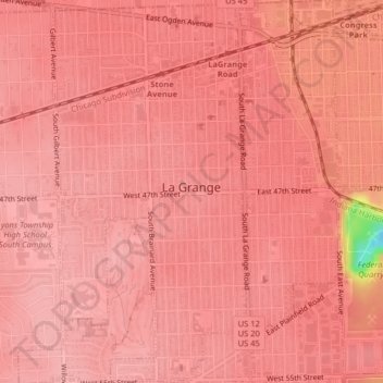
Naam: Topografische kaart La Grange, hoogte, reliëf.
Locatie: La Grange, Cook County, Illinois, United States of America (41.79017 -87.88943 41.82007 -87.85919)
Gemiddelde hoogte: 199 m
Minimale hoogte: 99 m
Maximale hoogte: 210 m
La Grange is located at 41°48′29″N 87°52′24″W / 41.80806°N 87.87333°W / 41.80806; -87.87333 (41.807938, -87.873455), about 13 miles (21 km) west of Chicago. The village is roughly flat, only deviating from the elevation of 645 feet by at most ten feet. La Grange is surrounded by incorporated places of similar sizes on all sides except to the South West, where the generously-named La Grange Highlands are.