
Doe een donatie
Rust jezelf uit voor je volgende avontuur:
Als Amazon-partner verdient deze site een commissie op in aanmerking komende aankopen, zonder extra kosten voor jou.
Topografische kaart Blue Ridge Summit
Klik op de kaart om de hoogte weer te geven.
Doe een donatie
Rust jezelf uit voor je volgende avontuur:
Als Amazon-partner verdient deze site een commissie op in aanmerking komende aankopen, zonder extra kosten voor jou.
Blue Ridge Summit
Pennsylvania Route 16 passes through Blue Ridge Summit, leading east down the mountain to Emmitsburg, Maryland, and west downhill to Waynesboro. The highway elevation at Blue Ridge Summit is 1,330 feet (410 m), compared to elevations of 500 and 700 feet (150 and 210 m) east and west of the mountain, respectively. Mount Dunlop, overlooking Blue Ridge Summit to the west, rises to a summit of 1,700 feet (520 m). Monterey Pass is northwest and slightly downhill from the community along PA 16.
Doe een donatie
Rust jezelf uit voor je volgende avontuur:
Als Amazon-partner verdient deze site een commissie op in aanmerking komende aankopen, zonder extra kosten voor jou.
Over deze kaart
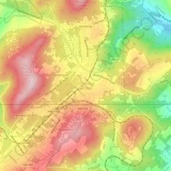
Naam: Topografische kaart Blue Ridge Summit, hoogte, reliëf.
Gemiddelde hoogte: 400 m
Minimale hoogte: 244 m
Maximale hoogte: 516 m
Doe een donatie
Rust jezelf uit voor je volgende avontuur:
Als Amazon-partner verdient deze site een commissie op in aanmerking komende aankopen, zonder extra kosten voor jou.