
Topografische kaart Lake Windsor
Interactieve kaart
Klik op de kaart om de hoogte weer te geven.
Over deze kaart
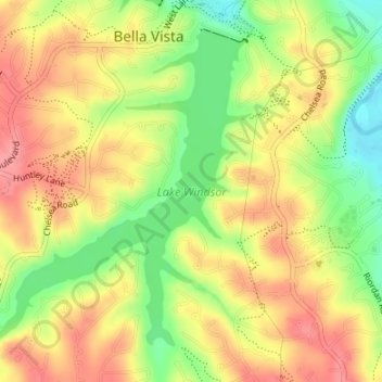
Naam: Topografische kaart Lake Windsor, hoogte, reliëf.
Gemiddelde hoogte: 352 m
Minimale hoogte: 302 m
Maximale hoogte: 391 m
Andere topografische kaarten
Klik op een kaart om zijn topografie, zijn hoogte en zijn reliëf te bekijken.
Lake Avalon
United States > Arkansas > Benton County > Bella Vista
Lake Avalon, Bella Vista, Benton County, Arkansas, 72715, United States
Gemiddelde hoogte: 353 m
Rago
United States > Arkansas > Benton County > Bella Vista
Rago, Bella Vista, Benton County, Arkansas, 72715, United States
Gemiddelde hoogte: 378 m
Loch Lomond
United States > Arkansas > Benton County > Bella Vista
Loch Lomond, Bella Vista, Benton County, Arkansas, 72715, United States
Gemiddelde hoogte: 360 m
Dug Hill
United States > Arkansas > Benton County > Bella Vista
Dug Hill, Bella Vista, Benton County, Arkansas, 72715, United States
Gemiddelde hoogte: 344 m
Bella Vista
United States > Arkansas > Benton County > Bella Vista > Bella Vista
Bella Vista, Benton County, Arkansas, 72715, United States
Gemiddelde hoogte: 359 m