
Topografische kaart Curraheen
Interactieve kaart
Klik op de kaart om de hoogte weer te geven.
Over deze kaart
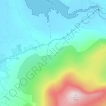
Naam: Topografische kaart Curraheen, hoogte, reliëf.
Gemiddelde hoogte: 124 m
Minimale hoogte: -1 m
Maximale hoogte: 489 m
Andere topografische kaarten
Klik op een kaart om zijn topografie, zijn hoogte en zijn reliëf te bekijken.
Kenmare Municipal District
Kenmare Municipal District, County Kerry, Munster, Irland
Gemiddelde hoogte: 98 m
An Coimín Theas
An Coimín Theas, Toghroinn ceantair Dún Chaoin, Kenmare Municipal District, County Kerry, Munster, Irland
Gemiddelde hoogte: 248 m
Valentia
Valentia, Kenmare Municipal District, County Kerry, Munster, Irland
Gemiddelde hoogte: 39 m
Ross Behy
Ross Behy, Glanbehy ED, Kenmare Municipal District, County Kerry, Munster, V93 H5W9, Irland
Gemiddelde hoogte: 57 m