
Topografische kaart Town of Clark's Harbour
Interactieve kaart
Klik op de kaart om de hoogte weer te geven.
Over deze kaart
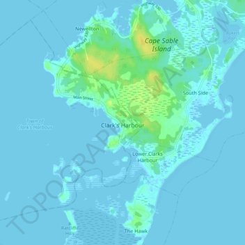
Naam: Topografische kaart Town of Clark's Harbour, hoogte, reliëf.
Gemiddelde hoogte: 2 m
Minimale hoogte: -3 m
Maximale hoogte: 21 m
Andere topografische kaarten
Klik op een kaart om zijn topografie, zijn hoogte en zijn reliëf te bekijken.
Ingomar
Canada > Nova Scotia > Shelburne County
Ingomar, Municipality of the District of Shelburne, Shelburne County, Nova Scotia, B0T 1W0, Canada
Gemiddelde hoogte: 5 m
Thomasville
Canada > Nova Scotia > Shelburne County
Thomasville, Municipality of the District of Barrington, Shelburne County, Nova Scotia, B0W 3L0, Canada
Gemiddelde hoogte: 4 m
Barrington Passage
Canada > Nova Scotia > Shelburne County
Barrington Passage, Municipality of the District of Barrington, Shelburne County, Nova Scotia, B0W 1E0, Canada
Gemiddelde hoogte: 13 m
Central Woods Harbour
Canada > Nova Scotia > Shelburne County
Central Woods Harbour, Municipality of the District of Barrington, Shelburne County, Nova Scotia, Canada
Gemiddelde hoogte: 12 m
Blanche
Canada > Nova Scotia > Shelburne County
Blanche, Municipality of the District of Barrington, Shelburne County, Nova Scotia, B0W 1K0, Canada
Gemiddelde hoogte: 2 m
Lower Shag Harbour
Canada > Nova Scotia > Shelburne County
Lower Shag Harbour, Municipality of the District of Barrington, Shelburne County, Nova Scotia, B0W 3B0, Canada
Gemiddelde hoogte: 8 m
Sandy Point
Canada > Nova Scotia > Shelburne County
Sandy Point, Municipality of the District of Shelburne, Shelburne County, Nova Scotia, B0T 1W0, Canada
Gemiddelde hoogte: 23 m
Stoney Island
Canada > Nova Scotia > Shelburne County
Stoney Island, Municipality of the District of Barrington, Shelburne County, Nova Scotia, B0W 1P0, Canada
Gemiddelde hoogte: 3 m
Cape Sable Island
Canada > Nova Scotia > Shelburne County > Clark's Harbour > Newellton
Cape Sable Island, Clark's Harbour, Newellton, Municipality of the District of Barrington, Shelburne County, Nova Scotia, B0W 1P0, Canada
Gemiddelde hoogte: 3 m
Shelburne
Canada > Nova Scotia > Shelburne County > Shelburne
Shelburne, Town of Shelburne, Shelburne County, Nova Scotia, Canada
Gemiddelde hoogte: 28 m
Barrington West
Canada > Nova Scotia > Shelburne County
Barrington West, Municipality of the District of Barrington, Shelburne County, Nova Scotia, B0W 1E0, Canada
Gemiddelde hoogte: 13 m
Town of Shelburne
Canada > Nova Scotia > Shelburne County
Town of Shelburne, Shelburne County, Nova Scotia, Canada
Gemiddelde hoogte: 29 m
North East Harbour
Canada > Nova Scotia > Shelburne County
North East Harbour, Municipality of the District of Shelburne, Shelburne County, Nova Scotia, B0T 1W0, Canada
Gemiddelde hoogte: 6 m
Wallace Lake
Canada > Nova Scotia > Shelburne County > Moosehead Island
Wallace Lake, Moosehead Island, Municipality of the District of Shelburne, Shelburne County, Nova Scotia, Canada
Gemiddelde hoogte: 102 m
West Green Harbour
Canada > Nova Scotia > Shelburne County
West Green Harbour, Municipality of the District of Shelburne, Shelburne County, Nova Scotia, B0T 1L0, Canada
Gemiddelde hoogte: 10 m
West Middle Sable
Canada > Nova Scotia > Shelburne County > West Middle Sable
West Middle Sable, Municipality of the District of Shelburne, Shelburne County, Nova Scotia, B0T 1V0, Canada
Gemiddelde hoogte: 19 m
Little Harbour
Canada > Nova Scotia > Shelburne County
Little Harbour, Municipality of the District of Shelburne, Shelburne County, Nova Scotia, Canada
Gemiddelde hoogte: 3 m
Shag Harbour
Canada > Nova Scotia > Shelburne County > Shag Harbour
Shag Harbour, Municipality of the District of Barrington, Shelburne County, Nova Scotia, B0W 3B0, Canada
Gemiddelde hoogte: 3 m
Woodlawn
Canada > Nova Scotia > Shelburne County > Woodlawn
Woodlawn, Municipality of the District of Shelburne, Shelburne County, Nova Scotia, B0T 1W0, Canada
Gemiddelde hoogte: 43 m
Canada Hill
Canada > Nova Scotia > Shelburne County > Canada Hill
Canada Hill, Municipality of the District of Shelburne, Shelburne County, Nova Scotia, B0T 1L0, Canada
Gemiddelde hoogte: 34 m
Sable River
Canada > Nova Scotia > Shelburne County
Sable River, Municipality of the District of Shelburne, Shelburne County, Nova Scotia, B0T 1J0, Canada
Gemiddelde hoogte: 50 m
Lockeport
Canada > Nova Scotia > Shelburne County > Lockeport
Lockeport, Town of Lockeport, Shelburne County, Nova Scotia, B0T 1L0, Canada
Gemiddelde hoogte: 7 m
Jordan Bay
Canada > Nova Scotia > Shelburne County
Jordan Bay, Municipality of the District of Shelburne, Shelburne County, Nova Scotia, B0T 1W0, Canada
Gemiddelde hoogte: 14 m
Port Saxon
Canada > Nova Scotia > Shelburne County > Port Saxon
Port Saxon, Municipality of the District of Shelburne, Shelburne County, Nova Scotia, B0T 1W0, Canada
Gemiddelde hoogte: 10 m
Johns Island
Canada > Nova Scotia > Shelburne County > Forbes Point
Johns Island, Forbes Point, Municipality of the District of Barrington, Shelburne County, Nova Scotia, B0W 2A0, Canada
Gemiddelde hoogte: 10 m
North East Point
Canada > Nova Scotia > Shelburne County > North East Point
North East Point, Municipality of the District of Barrington, Shelburne County, Nova Scotia, B0W 1P0, Canada
Gemiddelde hoogte: 5 m
Jordan Ferry
Canada > Nova Scotia > Shelburne County
Jordan Ferry, Municipality of the District of Shelburne, Shelburne County, Nova Scotia, B0T 1W0, Canada
Gemiddelde hoogte: 22 m
Atlantic
Canada > Nova Scotia > Shelburne County
Atlantic, Municipality of the District of Shelburne, Shelburne County, Nova Scotia, B0T 1W0, Canada
Gemiddelde hoogte: 6 m
Jordan Falls
Canada > Nova Scotia > Shelburne County
Jordan Falls, Municipality of the District of Shelburne, Shelburne County, Nova Scotia, B0T 1L0, Canada
Gemiddelde hoogte: 66 m
Barrington
Canada > Nova Scotia > Shelburne County > Barrington
Barrington, Municipality of the District of Barrington, Shelburne County, Nova Scotia, Canada
Gemiddelde hoogte: 23 m