
Doe een donatie
Rust jezelf uit voor je volgende avontuur:
Als Amazon-partner verdient deze site een commissie op in aanmerking komende aankopen, zonder extra kosten voor jou.
Topografische kaart Arnica Lake
Klik op de kaart om de hoogte weer te geven.
Doe een donatie
Rust jezelf uit voor je volgende avontuur:
Als Amazon-partner verdient deze site een commissie op in aanmerking komende aankopen, zonder extra kosten voor jou.
Over deze kaart
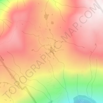
Naam: Topografische kaart Arnica Lake, hoogte, reliëf.
Gemiddelde hoogte: 1.180 m
Minimale hoogte: 499 m
Maximale hoogte: 1.559 m
Doe een donatie
Rust jezelf uit voor je volgende avontuur:
Als Amazon-partner verdient deze site een commissie op in aanmerking komende aankopen, zonder extra kosten voor jou.
Andere topografische kaarten
Klik op een kaart om zijn topografie, zijn hoogte en zijn reliëf te bekijken.
Kings Peak
Canada > British Columbia > Strathcona Regional District > Area D (Oyster Bay/Buttle Lake)
Gemiddelde hoogte: 1.435 m
Wolf Mountain
Canada > British Columbia > Strathcona Regional District > Area D (Oyster Bay/Buttle Lake)
Gemiddelde hoogte: 1.254 m
Upper Campbell Lake
Canada > British Columbia > Strathcona Regional District > Area D (Oyster Bay/Buttle Lake)
Gemiddelde hoogte: 632 m
Moving Glacier
Canada > British Columbia > Strathcona Regional District > Area D (Oyster Bay/Buttle Lake)
Gemiddelde hoogte: 1.539 m
Doe een donatie
Rust jezelf uit voor je volgende avontuur:
Als Amazon-partner verdient deze site een commissie op in aanmerking komende aankopen, zonder extra kosten voor jou.
Flower Ridge
Canada > British Columbia > Strathcona Regional District > Area D (Oyster Bay/Buttle Lake)
Gemiddelde hoogte: 1.095 m