
Topografische kaart Sogamoso
Interactieve kaart
Klik op de kaart om de hoogte weer te geven.
Sogamoso
Sogamoso (Spanish pronunciation: [soɣaˈmoso]) is a city in the department of Boyacá of Colombia. It is the capital of the Sugamuxi Province, named after the original Sugamuxi. Sogamoso is nicknamed "City of the Sun", based on the original Muisca tradition of pilgrimage and adoring their Sun god Sué at the Sun Temple. The city is located at an altitude of 2,569 metres (8,428 ft) on the Altiplano Cundiboyacense in the Eastern Ranges of the Colombian Andes.
Over deze kaart
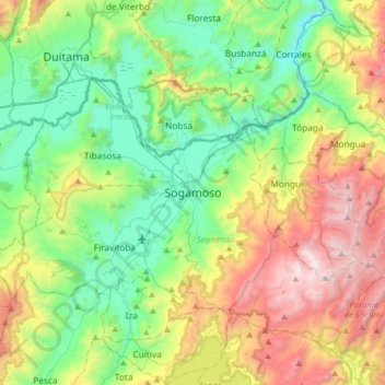
Naam: Topografische kaart Sogamoso, hoogte, reliëf.
Gemiddelde hoogte: 2.901 m
Minimale hoogte: 2.357 m
Maximale hoogte: 3.987 m