
Topografische kaart San Rafael
Interactieve kaart
Klik op de kaart om de hoogte weer te geven.
Over deze kaart
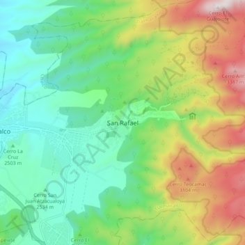
Naam: Topografische kaart San Rafael, hoogte, reliëf.
Locatie: San Rafael, Tlalmanalco, Estado de México, 56740, México (19.16944 -98.79706 19.24944 -98.71706)
Gemiddelde hoogte: 2.723 m
Minimale hoogte: 2.340 m
Maximale hoogte: 3.476 m
Andere topografische kaarten
Klik op een kaart om zijn topografie, zijn hoogte en zijn reliëf te bekijken.
Parque Nacional Iztaccíhuatl-Popocatépetl
México > Estado de México > Tlalmanalco
Parque Nacional Iztaccíhuatl-Popocatépetl, Tlalmanalco, Estado de México, México
Gemiddelde hoogte: 2.665 m