
Topografische kaart Aventura
Interactieve kaart
Klik op de kaart om de hoogte weer te geven.
Aventura
In addition to its sea-level elevation, coastal location and position just north of the Tropic of Cancer, the area owes its warm, humid climate to the Gulf Stream, which moderates climate year-round. A typical summer day does not see temperatures below 75 °F (24 °C). Temperatures in the high 80s to low 90s (30–35 °C) accompanied by high humidity are often relieved by afternoon thunderstorms or a sea breeze that develops off the Atlantic Ocean, which then allow lower temperatures, although conditions still remain very muggy. During winter, humidity is significantly lower, allowing for cooler weather to develop. Average minimum temperatures during that time are around 59 °F (15 °C), rarely dipping below 40 °F (4 °C), and the equivalent maxima usually around 75 °F (24 °C).
Over deze kaart
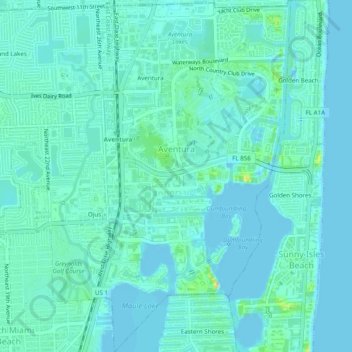
Naam: Topografische kaart Aventura, hoogte, reliëf.
Locatie: Aventura, Miami-Dade County, Florida, United States (25.93109 -80.15032 25.97505 -80.12331)
Gemiddelde hoogte: 7 m
Minimale hoogte: -2 m
Maximale hoogte: 36 m
Andere topografische kaarten
Klik op een kaart om zijn topografie, zijn hoogte en zijn reliëf te bekijken.
Harris Field
United States > Florida > Miami-Dade County > Homestead > Four Seasons Mobile Home Park
Gemiddelde hoogte: 4 m
Hibiscus Point Mobile Home Park
United States > Florida > Miami-Dade County > Hialeah
Gemiddelde hoogte: 8 m
West Little River
United States > Florida > Miami-Dade County > Miami > West Little River
Gemiddelde hoogte: 7 m
Strawberry Village Trailer Park
United States > Florida > Miami-Dade County > Hialeah
Gemiddelde hoogte: 6 m
Bal Harbor Beach
United States > Florida > Miami-Dade County > Bal Harbour Village
Gemiddelde hoogte: 3 m
Miami
United States > Florida > Miami-Dade County
Miami and its suburbs are located on a broad plain between the Everglades to the west and Biscayne Bay to the east, which extends from Lake Okeechobee southward to Florida Bay. The elevation of the area averages at around 6 ft (1.8 m) above sea level in most neighborhoods, especially near the coast. The…
Gemiddelde hoogte: 4 m
Key Biscayne
United States > Florida > Miami-Dade County
Key Biscayne lies south of Miami Beach and east of Miami. The village is connected to Miami via the Rickenbacker Causeway, originally built in 1947. Because of its low elevation and direct exposure to the Atlantic Ocean, it is usually among the first Miami areas to be evacuated before an oncoming hurricane.
Gemiddelde hoogte: 3 m
South Miami Heights
United States > Florida > Miami-Dade County > South Miami Heights
Gemiddelde hoogte: 6 m
Strawberry Village Trailer Park
United States > Florida > Miami-Dade County > Hialeah
Gemiddelde hoogte: 6 m
West Little River
United States > Florida > Miami-Dade County > West Little River
Gemiddelde hoogte: 7 m