
Topografische kaart Falimont
Interactieve kaart
Klik op de kaart om de hoogte weer te geven.
Over deze kaart
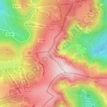
Naam: Topografische kaart Falimont, hoogte, reliëf.
Gemiddelde hoogte: 1.144 m
Minimale hoogte: 842 m
Maximale hoogte: 1.352 m
Andere topografische kaarten
Klik op een kaart om zijn topografie, zijn hoogte en zijn reliëf te bekijken.
Réserve naturelle du Frankenthal-Missheimle
France > Grand Est > Stosswihr
Réserve naturelle du Frankenthal-Missheimle, Sentier de la Bloy, Stosswihr, Colmar-Ribeauvillé, Haut-Rhin, Grand Est, France métropolitaine, 68140, France
Gemiddelde hoogte: 1.003 m
Lac de Schiessrothried
France > Grand Est > Stosswihr
Lac de Schiessrothried, Sentier des Couloirs, Stosswihr, Colmar-Ribeauvillé, Haut-Rhin, Grand Est, France métropolitaine, 68140, France
Gemiddelde hoogte: 1.074 m
La Grotte Dagobert
France > Grand Est > Stosswihr
La Grotte Dagobert, Sentier des Couloirs, Stosswihr, Colmar-Ribeauvillé, Haut-Rhin, Grand Est, France métropolitaine, 68140, France
Gemiddelde hoogte: 1.121 m
Petit Cervin
France > Grand Est > Stosswihr
Petit Cervin, Sentier du Falimont, Stosswihr, Colmar-Ribeauvillé, Haut-Rhin, Grand Est, France métropolitaine, 68140, France
Gemiddelde hoogte: 1.131 m