
Topografische kaart Kaber
Klik op de kaart om de hoogte weer te geven.
Over deze kaart
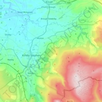
Naam: Topografische kaart Kaber, hoogte, reliëf.
Locatie: Kaber, Eden District, Cumbria, England, United Kingdom (54.44854 -2.33402 54.50662 -2.15937)
Gemiddelde hoogte: 305 m
Minimale hoogte: 139 m
Maximale hoogte: 661 m
Andere topografische kaarten
Klik op een kaart om zijn topografie, zijn hoogte en zijn reliëf te bekijken.
Smardale
United Kingdom > England > Cumbria > Eden District > Waitby > Smardale
Gemiddelde hoogte: 247 m
Black Fell Moss
United Kingdom > England > Cumbria > Eden District > Mallerstang
Gemiddelde hoogte: 588 m
Dufton Pike
United Kingdom > England > Cumbria > Eden District
Dufton Pike is a hill in the northern Pennines, in Cumbria, England. It is classed as a Marilyn (a hill with topographic prominence of at least 150m). It rises above the village of Dufton.
Gemiddelde hoogte: 313 m