
Topografische kaart Roxboro
Interactieve kaart
Klik op de kaart om de hoogte weer te geven.
Roxboro
Roxboro receives an average of 7.2 in (183 mm) of snow per winter. Freezing rain and sleet occur most winters, and occasionally the area experiences a major, damaging ice storm. Roxboro is often dubbed the "Snow Capital of the Triangle" because it often receives the most or close to the most snow during snowstorms in central North Carolina due to its high elevation.
Over deze kaart
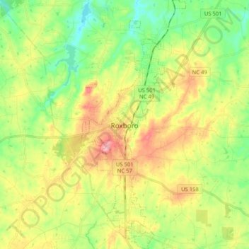
Naam: Topografische kaart Roxboro, hoogte, reliëf.
Locatie: Roxboro, Person County, North Carolina, United States (36.33009 -79.01072 36.45819 -78.94375)
Gemiddelde hoogte: 191 m
Minimale hoogte: 134 m
Maximale hoogte: 270 m
Andere topografische kaarten
Klik op een kaart om zijn topografie, zijn hoogte en zijn reliëf te bekijken.