
Topografische kaart Devils Fork State Park
Interactieve kaart
Klik op de kaart om de hoogte weer te geven.
Over deze kaart
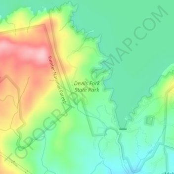
Naam: Topografische kaart Devils Fork State Park, hoogte, reliëf.
Gemiddelde hoogte: 365 m
Minimale hoogte: 304 m
Maximale hoogte: 473 m
Andere topografische kaarten
Klik op een kaart om zijn topografie, zijn hoogte en zijn reliëf te bekijken.
Lake Keowee
United States > South Carolina > Oconee County > Seneca
Lake Keowee, Seneca, Oconee County, South Carolina, 29672, United States
Gemiddelde hoogte: 292 m
Walhalla
United States > South Carolina > Oconee County
Walhalla, Oconee County, South Carolina, 29691, United States
Gemiddelde hoogte: 296 m
Stone Haven
United States > South Carolina > Oconee County
Stone Haven, Oconee County, South Carolina, 29361, United States
Gemiddelde hoogte: 227 m
Seneca
United States > South Carolina > Oconee County
Seneca, Oconee County, South Carolina, United States
Gemiddelde hoogte: 265 m
Oconee State Park
United States > South Carolina > Oconee County
Oconee State Park, Oconee County, South Carolina, United States
Gemiddelde hoogte: 518 m
Thriftwood
United States > South Carolina > Oconee County > Seneca
Thriftwood, Seneca, Oconee County, South Carolina, 29679, United States
Gemiddelde hoogte: 269 m
Tamassee
United States > South Carolina > Oconee County > Tamassee
Tamassee, Oconee County, South Carolina, 29686, United States
Gemiddelde hoogte: 323 m
Salem
United States > South Carolina > Oconee County
Salem, Oconee County, South Carolina, United States
Gemiddelde hoogte: 316 m
Boones Creek
United States > South Carolina > Oconee County > Boones Creek
Boones Creek, Oconee County, South Carolina, 29676, United States
Gemiddelde hoogte: 338 m
Lake Hartwell State Park
United States > South Carolina > Oconee County > Fairplay Shores
Lake Hartwell State Park, Fairplay Shores, Oconee County, South Carolina, United States
Gemiddelde hoogte: 213 m
Walhalla
United States > South Carolina > Oconee County > Walhalla > Walhalla
Walhalla, Oconee County, South Carolina, 29691, United States
Gemiddelde hoogte: 296 m
Long Creek
United States > South Carolina > Oconee County > Long Creek
Long Creek, Oconee County, South Carolina, 29658, United States
Gemiddelde hoogte: 479 m
Westminster
United States > South Carolina > Oconee County
Westminster, Oconee County, South Carolina, United States
Gemiddelde hoogte: 272 m
Fair Play
United States > South Carolina > Oconee County
Fair Play, Oconee County, South Carolina, 29643, United States
Gemiddelde hoogte: 233 m
Mountain Rest
United States > South Carolina > Oconee County
Mountain Rest, Oconee County, South Carolina, 29664, United States
Gemiddelde hoogte: 519 m