
Topografische kaart Begusarai
Interactieve kaart
Klik op de kaart om de hoogte weer te geven.
Over deze kaart
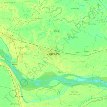
Naam: Topografische kaart Begusarai, hoogte, reliëf.
Locatie: Begusarai, Begusarai District, Bihar, 851117, India (25.25386 85.97489 25.57386 86.29489)
Gemiddelde hoogte: 41 m
Minimale hoogte: 32 m
Maximale hoogte: 55 m
Begusarai is located at 25°25′N 86°08′E / 25.42°N 86.13°E / 25.42; 86.13. It has an average elevation of 41 metres (134 feet). Begusarai lies in North Bihar and is surrounded by Khagaria in the northeast, Munger in the southeast, Patna in the west, and Samastipur in the northwest.