
Topografische kaart Cardington
Klik op de kaart om de hoogte weer te geven.
Over deze kaart
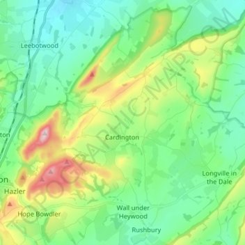
Naam: Topografische kaart Cardington, hoogte, reliëf.
Locatie: Cardington, Shropshire, England, United Kingdom (52.53157 -2.77622 52.58312 -2.64678)
Gemiddelde hoogte: 210 m
Minimale hoogte: 117 m
Maximale hoogte: 454 m
Andere topografische kaarten
Klik op een kaart om zijn topografie, zijn hoogte en zijn reliëf te bekijken.
Minton
United Kingdom > England > Shropshire > Church Stretton > Little Stretton
Gemiddelde hoogte: 272 m