
Topografische kaart Glendiheen
Interactieve kaart
Klik op de kaart om de hoogte weer te geven.
Over deze kaart
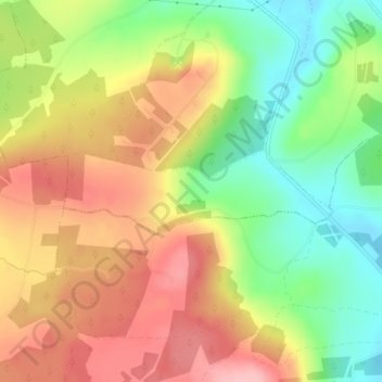
Naam: Topografische kaart Glendiheen, hoogte, reliëf.
Gemiddelde hoogte: 167 m
Minimale hoogte: 95 m
Maximale hoogte: 235 m
Andere topografische kaarten
Klik op een kaart om zijn topografie, zijn hoogte en zijn reliëf te bekijken.
Knocknabooly East
Ireland > The Municipal District of Adare — Rathkeale
Knocknabooly East, Loghill, The Municipal District of Adare — Rathkeale, County Limerick, Munster, Ireland
Gemiddelde hoogte: 105 m
Shanagolden
Ireland > The Municipal District of Adare — Rathkeale
Shanagolden, The Municipal District of Adare — Rathkeale, County Limerick, Munster, Ireland
Gemiddelde hoogte: 40 m
Pallaskenry
Ireland > The Municipal District of Adare — Rathkeale
Pallaskenry, The Municipal District of Adare — Rathkeale, County Limerick, Munster, Ireland
Gemiddelde hoogte: 11 m
Kildimo
Ireland > The Municipal District of Adare — Rathkeale
Kildimo, The Municipal District of Adare — Rathkeale, County Limerick, Munster, Ireland
Gemiddelde hoogte: 14 m
Loghill
Ireland > The Municipal District of Adare — Rathkeale
Loghill, The Municipal District of Adare — Rathkeale, County Limerick, Munster, Ireland
Gemiddelde hoogte: 69 m
Ballinknockane
Ireland > The Municipal District of Adare — Rathkeale
Ballinknockane, Craggs, The Municipal District of Adare — Rathkeale, County Limerick, Munster, Ireland
Gemiddelde hoogte: 27 m
Inchinclare
Ireland > The Municipal District of Adare — Rathkeale
Inchinclare, Ballynabanoge, The Municipal District of Adare — Rathkeale, County Limerick, Munster, Ireland
Gemiddelde hoogte: 41 m
Clonshire Beg
Ireland > The Municipal District of Adare — Rathkeale
Clonshire Beg, Croagh, The Municipal District of Adare — Rathkeale, County Limerick, Munster, Ireland
Gemiddelde hoogte: 13 m
Foynes Island
Ireland > The Municipal District of Adare — Rathkeale
Foynes Island, Shanagolden, The Municipal District of Adare — Rathkeale, County Limerick, Munster, Ireland
Gemiddelde hoogte: 10 m