
Topografische kaart Elizabeth Metis Settlement
Interactieve kaart
Klik op de kaart om de hoogte weer te geven.
Over deze kaart
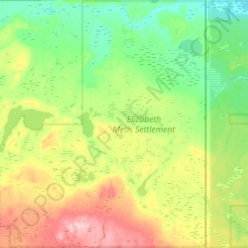
Naam: Topografische kaart Elizabeth Metis Settlement, hoogte, reliëf.
Gemiddelde hoogte: 607 m
Minimale hoogte: 533 m
Maximale hoogte: 747 m
Andere topografische kaarten
Klik op een kaart om zijn topografie, zijn hoogte en zijn reliëf te bekijken.
Crane Lake
Canada > Alberta > Municipal District of Bonnyville > Happy Hollow
Crane Lake, Happy Hollow, Municipal District of Bonnyville, Alberta, Canada
Gemiddelde hoogte: 562 m
Bourque Lake
Canada > Alberta > Municipal District of Bonnyville
Bourque Lake, Municipal District of Bonnyville, Alberta, Canada
Gemiddelde hoogte: 617 m
Hilda Lake
Canada > Alberta > Municipal District of Bonnyville
Hilda Lake, Municipal District of Bonnyville, Alberta, Canada
Gemiddelde hoogte: 555 m