
Topografische kaart White Pine County
Interactieve kaart
Klik op de kaart om de hoogte weer te geven.
Over deze kaart
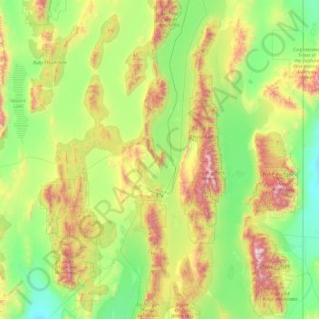
Naam: Topografische kaart White Pine County, hoogte, reliëf.
Locatie: White Pine County, Nevada, United States of America (38.67751 -115.90822 40.12890 -114.04639)
Gemiddelde hoogte: 2.049 m
Minimale hoogte: 1.468 m
Maximale hoogte: 3.839 m
In the southeastern part of the county within Great Basin National Park lies 13,065 ft (3982 m) Wheeler Peak, the tallest independent mountain within Nevada and the second-highest point within the state (the highest point being Boundary Peak). It is also the most topographically prominent peak in the county and the second-most prominent peak in Nevada (after Mount Charleston).