
Doe een donatie
Rust jezelf uit voor je volgende avontuur:
Als Amazon-partner verdient deze site een commissie op in aanmerking komende aankopen, zonder extra kosten voor jou.
Topografische kaart Hills
Klik op de kaart om de hoogte weer te geven.
Doe een donatie
Rust jezelf uit voor je volgende avontuur:
Als Amazon-partner verdient deze site een commissie op in aanmerking komende aankopen, zonder extra kosten voor jou.
Hills
According to the United States Census Bureau, the city has a total area of 0.54 square miles (1.40 km2); 0.53 square miles (1.37 km2) is land and 0.01 square miles (0.03 km2) is water. The landscape is flat with some gently rolling hills; however, the town's name does not derive from a particular topographical feature. The town includes two parks, Jacobson Park and the Rez. The Rez is a man made reservoir that is used for swimming, fishing and outdoor recreation. A gravel path circles the Rez (reservoir) and there are two small playgrounds. Multiple campsites and a cabin are also on the property as well as a disc golf course.
Doe een donatie
Rust jezelf uit voor je volgende avontuur:
Als Amazon-partner verdient deze site een commissie op in aanmerking komende aankopen, zonder extra kosten voor jou.
Over deze kaart
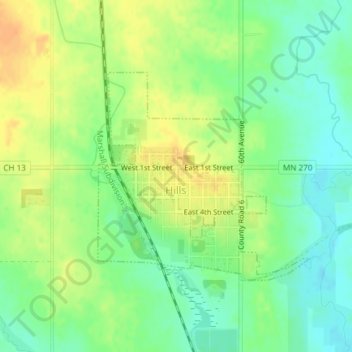
Naam: Topografische kaart Hills, hoogte, reliëf.
Gemiddelde hoogte: 445 m
Minimale hoogte: 429 m
Maximale hoogte: 463 m
Doe een donatie
Rust jezelf uit voor je volgende avontuur:
Als Amazon-partner verdient deze site een commissie op in aanmerking komende aankopen, zonder extra kosten voor jou.