
Topografische kaart Xora
Interactieve kaart
Klik op de kaart om de hoogte weer te geven.
Over deze kaart
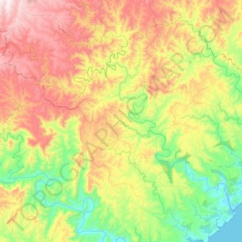
Naam: Topografische kaart Xora, hoogte, reliëf.
Gemiddelde hoogte: 324 m
Minimale hoogte: -3 m
Maximale hoogte: 773 m
Andere topografische kaarten
Klik op een kaart om zijn topografie, zijn hoogte en zijn reliëf te bekijken.
Nqabara
RSA > Eastern Cape > Mbhashe Local Municipality
Nqabara, Mbhashe Local Municipality, Amathole District Municipality, Eastern Cape, 5040, RSA
Gemiddelde hoogte: 238 m