
Topografische kaart Mukkam
Interactieve kaart
Klik op de kaart om de hoogte weer te geven.
Over deze kaart
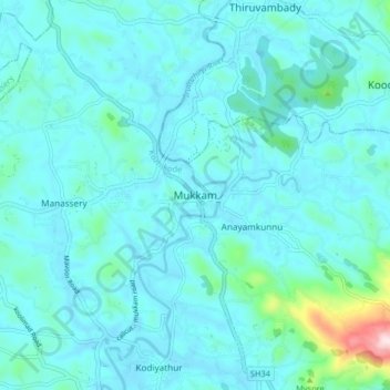
Naam: Topografische kaart Mukkam, hoogte, reliëf.
Locatie: Mukkam, Kozhikode, Kozhikode district, Kerala, 673602, India (11.28248 75.95488 11.36248 76.03488)
Gemiddelde hoogte: 50 m
Minimale hoogte: 4 m
Maximale hoogte: 433 m
Andere topografische kaarten
Klik op een kaart om zijn topografie, zijn hoogte en zijn reliëf te bekijken.
Vellimadukunnu
India > Kerala > Kozhikode > Kozhikode
Vellimadukunnu, Kozhikode, Kozhikode District, Kerala, India
Gemiddelde hoogte: 27 m
Parambil Bazar
Parambil Bazar, Kozhikode, Kozhikode District, Kerala, 673012, India
Gemiddelde hoogte: 25 m
Kodampuzha
India > Kerala > Kozhikode > Faroke - Petta
Kodampuzha, Cheruvannur, Faroke - Petta, Kozhikode, Kozhikode district, Kerala, 673631, India
Gemiddelde hoogte: 14 m
Ramanattukara
India > Kerala > Kozhikode > Ramanattukara
Ramanattukara, Kozhikode, Kozhikode district, Kerala, 673633, India
Gemiddelde hoogte: 24 m
Kandamkulangara
India > Kerala > Kozhikode > Kandamkulangara
Kandamkulangara, Kozhikode, Kozhikode district, Kerala, 673021, India
Gemiddelde hoogte: 11 m
Velliparamba
India > Kerala > Kozhikode > Kozhikode > Velliparamba
Velliparamba, Kozhikode, Kozhikode district, Kerala, 673 016, India
Gemiddelde hoogte: 30 m
Kunnamangalam
Kunnamangalam, Kozhikode, Kozhikode District, Kerala, 673571, India
Gemiddelde hoogte: 35 m
Chevarambalam
India > Kerala > Kozhikode > Kozhikode
Chevarambalam, NGO Quarters, Kozhikode, Kozhikode district, Kerala, India
Gemiddelde hoogte: 23 m
Thadambattuthazham
India > Kerala > Kozhikode > Thadambattuthazham
Thadambattuthazham, Kozhikode, Kozhikode district, Kerala, 673010, India
Gemiddelde hoogte: 17 m