
Topografische kaart Aberystwyth
Interactieve kaart
Klik op de kaart om de hoogte weer te geven.
Over deze kaart
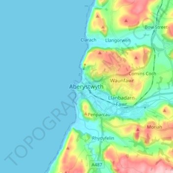
Naam: Topografische kaart Aberystwyth, hoogte, reliëf.
Locatie: Aberystwyth, Ceredigion, Wales, SY23 1LH, United Kingdom (52.37431 -4.12168 52.45431 -4.04168)
Gemiddelde hoogte: 39 m
Minimale hoogte: -1 m
Maximale hoogte: 195 m
Aberystwyth experiences an oceanic climate (Köppen climate classification Cfb) similar to almost all of the United Kingdom. This is particularly pronounced due to its west coast location facing the Irish Sea. Air undergoes little land moderation and so temperatures closely reflect the sea temperature when winds are coming from the predominant onshore (westerly) direction. The nearest Met Office weather station is Gogerddan, 3 miles to the northeast, and at a similar elevation.
Andere topografische kaarten
Klik op een kaart om zijn topografie, zijn hoogte en zijn reliëf te bekijken.
Aberporth
United Kingdom > Wales > Ceredigion
Aberporth, Ceredigion, Wales, SA43 2DB, United Kingdom
Gemiddelde hoogte: 62 m
Cardigan
United Kingdom > Wales > Ceredigion > Cardigan
Cardigan, Ceredigion, Wales, SA43 1JR, United Kingdom
Gemiddelde hoogte: 81 m
Ynyslas
United Kingdom > Wales > Ceredigion > Borth > Ynyslas
Ynyslas, Borth, Ceredigion, Wales, SY24 5JX, United Kingdom
Gemiddelde hoogte: 1 m
Plynlimon
United Kingdom > Wales > Ceredigion
Plynlimon, Ceredigion, Wales, SY23 3AG, United Kingdom
Gemiddelde hoogte: 583 m